
Carte topographique Nevada
Carte interactive
Cliquez sur la carte pour afficher l’altitude.
À propos de cette carte
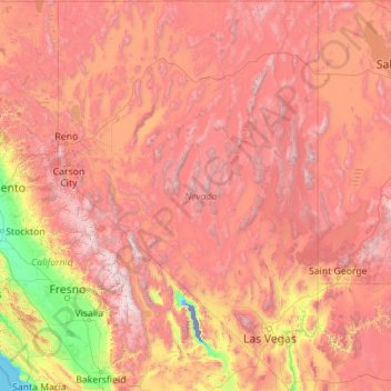
Nom : Carte topographique Nevada, altitude, relief.
Lieu : Nevada, United States (35.00189 -120.00573 42.00038 -114.04030)
Altitude moyenne : 1.475 m
Altitude minimum : -82 m
Altitude maximum : 4.264 m
Much of the northern part of the state is within the Great Basin, a mild desert that experiences hot temperatures in the summer and cold temperatures in the winter. Occasionally, moisture from the Arizona Monsoon will cause summer thunderstorms; Pacific storms may blanket the area with snow. The state's highest recorded temperature was 125 °F (52 °C) in Laughlin (elevation of 605 feet or 184 meters) on June 29, 1994. The coldest recorded temperature was −52 °F (−47 °C) set in San Jacinto in 1972, in the northeastern portion of the state.
Autres cartes topographiques
Cliquez sur une carte pour visualiser sa topographie, son altitude et son relief.
Houston
United States > Texas > Harris County
Houston, Harris County, Texas, United States
Altitude moyenne : 25 m
Boulder
United States > Colorado > Boulder County
Boulder, Boulder County, Colorado, United States
Altitude moyenne : 1.785 m
Montgomery County
Montgomery County, Texas, United States
Altitude moyenne : 69 m
Los Angeles
Los Angeles, Los Angeles County, California, United States
Altitude moyenne : 241 m
The Woodlands
United States > Texas > Montgomery County
The Woodlands, Montgomery County, Texas, United States
Altitude moyenne : 47 m
Spokane
United States > Washington > Spokane County
Spokane, Spokane County, Washington, United States
Altitude moyenne : 655 m
Lancaster County
Lancaster County, Pennsylvania, United States
Altitude moyenne : 158 m
Hudson River
Hudson River, New Jersey, 12834:12871, United States
Altitude moyenne : 297 m
Fort Worth
United States > Texas > Tarrant County
Fort Worth, Tarrant County, Texas, United States
Altitude moyenne : 212 m
Brooklyn
United States > New York > New York
Brooklyn, Kings County, New York, United States
Altitude moyenne : 9 m
Tomball
United States > Texas > Harris County
Tomball, Harris County, Texas, 77375, United States
Altitude moyenne : 52 m
New Orleans
United States > Louisiana > Orleans Parish
New Orleans, Orleans Parish, Louisiana, United States
Altitude moyenne : 1 m
Sequoia National Park
United States > California > Tulare County
Sequoia National Park, Tulare County, California, United States
Altitude moyenne : 2.515 m
Queens County
United States > New York > New York
Queens County, New York, United States
Altitude moyenne : 11 m
Black Hills
United States > South Dakota > Pennington County
Black Hills, Pennington County, South Dakota, United States
Altitude moyenne : 1.894 m
Saint Johns County
Saint Johns County, Florida, United States
Altitude moyenne : 6 m