
Faire un don
Équipez-vous pour votre prochaine aventure :
En tant que Partenaire Amazon, ce site perçoit une commission sur les achats éligibles sans surcoût pour vous.
Carte topographique New Jersey
Cliquez sur la carte pour afficher l’altitude.
Faire un don
Équipez-vous pour votre prochaine aventure :
En tant que Partenaire Amazon, ce site perçoit une commission sur les achats éligibles sans surcoût pour vous.
New Jersey
Selon la classification de Köppen, le Sud, le Centre et le Nord-Est de l'État jouissent d'un climat subtropical humide tandis que le Nord-Ouest jouit d'un climat continental humide, avec des températures plus fraîches en raison de l'altitude.
Faire un don
Équipez-vous pour votre prochaine aventure :
En tant que Partenaire Amazon, ce site perçoit une commission sur les achats éligibles sans surcoût pour vous.
À propos de cette carte
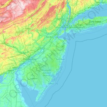
Nom : Carte topographique New Jersey, altitude, relief.
Lieu : New Jersey, États-Unis d'Amérique (38.79113 -75.56339 41.35745 -73.89363)
Altitude moyenne : 72 m
Altitude minimum : -5 m
Altitude maximum : 671 m
Faire un don
Équipez-vous pour votre prochaine aventure :
En tant que Partenaire Amazon, ce site perçoit une commission sur les achats éligibles sans surcoût pour vous.
Autres cartes topographiques
Cliquez sur une carte pour visualiser sa topographie, son altitude et son relief.
Montagnes Rocheuses
États-Unis d'Amérique > Wyoming > Teton County
Leur altitude varie entre 1 500 m près des hautes plaines et 4 399 m au mont Elbert dans le Colorado. Leur largeur est comprise entre 120 et 650 km. Elles prennent une forme oblongue, étendue en latitude sur plusieurs milliers de kilomètres.
Altitude moyenne : 2.292 m
Faire un don
Équipez-vous pour votre prochaine aventure :
En tant que Partenaire Amazon, ce site perçoit une commission sur les achats éligibles sans surcoût pour vous.
Monument Valley Navajo Tribal Park
États-Unis d'Amérique > Arizona > Navajo County
Monument Valley connaît un climat désertique avec des hivers froids et des étés chauds. Ces derniers sont toutefois tempérés par l'altitude de la région : alors que la température excède 32 °C durant 54 jours en moyenne par an, elle dépasse rarement 38 °C sur les hauteurs. Les nuits sont fraîches,…
Altitude moyenne : 1.675 m
Faire un don
Équipez-vous pour votre prochaine aventure :
En tant que Partenaire Amazon, ce site perçoit une commission sur les achats éligibles sans surcoût pour vous.
Faire un don
Équipez-vous pour votre prochaine aventure :
En tant que Partenaire Amazon, ce site perçoit une commission sur les achats éligibles sans surcoût pour vous.
Mont Fairweather
États-Unis d'Amérique > Alaska > Yakutat
Le mont Fairweather (Mount Fairweather aux États-Unis, Fairweather Mountain au Canada) est un sommet s'élevant à 4 663 ou 4 671 mètres d'altitude entre l'État américain d'Alaska et la province canadienne de Colombie-Britannique et constituant le point culminant de cette dernière, ainsi que du chaînon…
Altitude moyenne : 3.845 m
Faire un don
Équipez-vous pour votre prochaine aventure :
En tant que Partenaire Amazon, ce site perçoit une commission sur les achats éligibles sans surcoût pour vous.
Cherry River
États-Unis d'Amérique > Virginie-Occidentale > Nicholas County > Richwood
Altitude moyenne : 787 m
Faire un don
Équipez-vous pour votre prochaine aventure :
En tant que Partenaire Amazon, ce site perçoit une commission sur les achats éligibles sans surcoût pour vous.
West Barnstable
États-Unis d'Amérique > Massachusetts > Barnstable County > West Barnstable
Altitude moyenne : 15 m
Faire un don
Équipez-vous pour votre prochaine aventure :
En tant que Partenaire Amazon, ce site perçoit une commission sur les achats éligibles sans surcoût pour vous.
White Mountain
États-Unis d'Amérique > Alaska > Unorganized Borough > White Mountain
Altitude moyenne : 25 m
Faire un don
Équipez-vous pour votre prochaine aventure :
En tant que Partenaire Amazon, ce site perçoit une commission sur les achats éligibles sans surcoût pour vous.
Grand Canyon
États-Unis d'Amérique > Arizona > Coconino County
Le climat est marqué par l'aridité et l'altitude. Les précipitations annuelles sur South Rim sont de 380 mm. Les températures varient entre le nord (plus froid car plus élevé) et le sud du parc. Elles sont différentes selon que l'on se trouve sur le plateau ou au fond du canyon : l'été est…
Altitude moyenne : 1.021 m
Faire un don
Équipez-vous pour votre prochaine aventure :
En tant que Partenaire Amazon, ce site perçoit une commission sur les achats éligibles sans surcoût pour vous.
Morro Rock
États-Unis d'Amérique > Californie > San Luis Obispo County > Morro Bay
Altitude moyenne : 3 m
Faire un don
Équipez-vous pour votre prochaine aventure :
En tant que Partenaire Amazon, ce site perçoit une commission sur les achats éligibles sans surcoût pour vous.
Faire un don
Équipez-vous pour votre prochaine aventure :
En tant que Partenaire Amazon, ce site perçoit une commission sur les achats éligibles sans surcoût pour vous.
Niagara Escarpment
États-Unis d'Amérique > New York > Niagara County > City of Lockport
Altitude moyenne : 165 m
Faire un don
Équipez-vous pour votre prochaine aventure :
En tant que Partenaire Amazon, ce site perçoit une commission sur les achats éligibles sans surcoût pour vous.
10
États-Unis d'Amérique > Virginie-Occidentale > Pocahontas County > Snowshoe
Altitude moyenne : 1.164 m
Lac Francis
États-Unis d'Amérique > New Hampshire > Coos County > Clarksville
Altitude moyenne : 498 m
Faire un don
Équipez-vous pour votre prochaine aventure :
En tant que Partenaire Amazon, ce site perçoit une commission sur les achats éligibles sans surcoût pour vous.
Bodie
États-Unis d'Amérique > Californie > Mono County
Bodie est une ville fantôme située en Californie, sur le versant oriental de la Sierra Nevada, dans le comté de Mono, à environ 120 km au sud-est du Lac Tahoe à une altitude de 2 550 m.
Altitude moyenne : 2.627 m
Faire un don
Équipez-vous pour votre prochaine aventure :
En tant que Partenaire Amazon, ce site perçoit une commission sur les achats éligibles sans surcoût pour vous.
Denali
États-Unis d'Amérique > Alaska > Denali
Le Denali, appelé mont McKinley de 1896 à 2015, est une montagne s'élevant à 6 190 mètres d'altitude dans la chaîne d'Alaska, dans l'État du même nom aux États-Unis. Il constitue le point culminant de l'Amérique du Nord et fait donc partie des sept sommets. Il est couvert de glaciers.
Altitude moyenne : 5.546 m
Paradise Beach
États-Unis d'Amérique > New York > Warren County > Town of Queensbury
Altitude moyenne : 132 m
Faire un don
Équipez-vous pour votre prochaine aventure :
En tant que Partenaire Amazon, ce site perçoit une commission sur les achats éligibles sans surcoût pour vous.
Osbornes Mills
États-Unis d'Amérique > New Jersey > Monmouth County > Wall Township
Altitude moyenne : 14 m
Algonquin Park
États-Unis d'Amérique > Kentucky > Jefferson County > Louisville > South Parkland
Altitude moyenne : 141 m
White Harbor
États-Unis d'Amérique > Mississippi > Harrison County > Pass Christian
Altitude moyenne : 5 m
Faire un don
Équipez-vous pour votre prochaine aventure :
En tant que Partenaire Amazon, ce site perçoit une commission sur les achats éligibles sans surcoût pour vous.
Pikes Peak
États-Unis d'Amérique > Colorado > El Paso County
Le pic Pikes, ou Pikes Peak selon son nom anglais, anciennement Pike's Peak, est une montagne culminant à 4 301 mètres d'altitude dans la Front Range des montagnes Rocheuses, dans l'État américain du Colorado. Particulièrement visible depuis les Grandes Plaines et facilement accessible depuis les environs…
Altitude moyenne : 3.902 m
Faire un don
Équipez-vous pour votre prochaine aventure :
En tant que Partenaire Amazon, ce site perçoit une commission sur les achats éligibles sans surcoût pour vous.
Faire un don
Équipez-vous pour votre prochaine aventure :
En tant que Partenaire Amazon, ce site perçoit une commission sur les achats éligibles sans surcoût pour vous.
Tin City
États-Unis d'Amérique > Californie > San Luis Obispo County > Cambria
Altitude moyenne : 73 m
Faire un don
Équipez-vous pour votre prochaine aventure :
En tant que Partenaire Amazon, ce site perçoit une commission sur les achats éligibles sans surcoût pour vous.
Lac Michel
États-Unis d'Amérique > Missouri > St. Francois County > Terre Du Lac
Altitude moyenne : 287 m
Faire un don
Équipez-vous pour votre prochaine aventure :
En tant que Partenaire Amazon, ce site perçoit une commission sur les achats éligibles sans surcoût pour vous.
Faire un don
Équipez-vous pour votre prochaine aventure :
En tant que Partenaire Amazon, ce site perçoit une commission sur les achats éligibles sans surcoût pour vous.
Faire un don
Équipez-vous pour votre prochaine aventure :
En tant que Partenaire Amazon, ce site perçoit une commission sur les achats éligibles sans surcoût pour vous.
Faire un don
Équipez-vous pour votre prochaine aventure :
En tant que Partenaire Amazon, ce site perçoit une commission sur les achats éligibles sans surcoût pour vous.
Willimansett
États-Unis d'Amérique > Massachusetts > Hampden County > Chicopee
Altitude moyenne : 51 m
Faire un don
Équipez-vous pour votre prochaine aventure :
En tant que Partenaire Amazon, ce site perçoit une commission sur les achats éligibles sans surcoût pour vous.
Faire un don
Équipez-vous pour votre prochaine aventure :
En tant que Partenaire Amazon, ce site perçoit une commission sur les achats éligibles sans surcoût pour vous.
Cover Hill
États-Unis d'Amérique > Pennsylvanie > Somerset County > Brothersvalley Township
Altitude moyenne : 768 m
Faire un don
Équipez-vous pour votre prochaine aventure :
En tant que Partenaire Amazon, ce site perçoit une commission sur les achats éligibles sans surcoût pour vous.