
Faire un don
Équipez-vous pour votre prochaine aventure :
En tant que Partenaire Amazon, ce site perçoit une commission sur les achats éligibles sans surcoût pour vous.
Carte topographique Utah
Cliquez sur la carte pour afficher l’altitude.
Faire un don
Équipez-vous pour votre prochaine aventure :
En tant que Partenaire Amazon, ce site perçoit une commission sur les achats éligibles sans surcoût pour vous.
Utah
À plus de 2 000 m d'altitude, des milliers d'aiguilles et de flèches de calcaire orange, roses, blanches se dressent vers le ciel au parc national de Bryce Canyon, l'un des plus célèbres sites de l'Utah. La nature a mis soixante millions d'années à les façonner. Et son œuvre continue encore aujourd'hui.
Faire un don
Équipez-vous pour votre prochaine aventure :
En tant que Partenaire Amazon, ce site perçoit une commission sur les achats éligibles sans surcoût pour vous.
À propos de cette carte
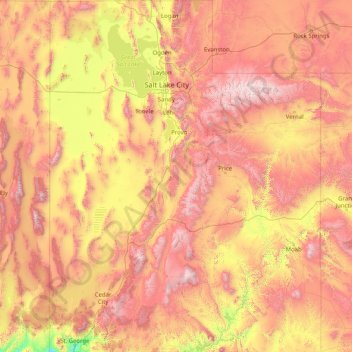
Nom : Carte topographique Utah, altitude, relief.
Lieu : Utah, États-Unis d'Amérique (36.99781 -114.05285 42.00170 -109.04158)
Altitude moyenne : 1.876 m
Altitude minimum : 789 m
Altitude maximum : 3.986 m
Faire un don
Équipez-vous pour votre prochaine aventure :
En tant que Partenaire Amazon, ce site perçoit une commission sur les achats éligibles sans surcoût pour vous.
Autres cartes topographiques
Cliquez sur une carte pour visualiser sa topographie, son altitude et son relief.
Montagnes Rocheuses
États-Unis d'Amérique > Wyoming > Teton County
Leur altitude varie entre 1 500 m près des hautes plaines et 4 399 m au mont Elbert dans le Colorado. Leur largeur est comprise entre 120 et 650 km. Elles prennent une forme oblongue, étendue en latitude sur plusieurs milliers de kilomètres.
Altitude moyenne : 2.292 m
Faire un don
Équipez-vous pour votre prochaine aventure :
En tant que Partenaire Amazon, ce site perçoit une commission sur les achats éligibles sans surcoût pour vous.
Appalaches
États-Unis d'Amérique > Caroline du Nord > Yancey County
La chaîne des Appalaches occupe dans sa plus grande partie le territoire américain et déborde sur le sud-est du Canada. Elle s'étend entre la latitude 49°N (monts Chic-Chocs au Québec, Canada) et la latitude 32°N (Alabama, États-Unis). Le point culminant de la partie canadienne du massif est le mont…
Altitude moyenne : 1.463 m
Los Angeles
États-Unis d'Amérique > Californie > Los Angeles County
L'altitude maximale sur la commune est de 1 548 m au Sister Elsie Peak. Le territoire de la ville de Los Angeles est si vaste qu'elle est généralement divisée en plusieurs grands secteurs : Downtown Los Angeles (Central L.A), Eastside, Wilshire, Hollywood, Northwest, South Los Angeles (anciennement South…
Altitude moyenne : 144 m
Faire un don
Équipez-vous pour votre prochaine aventure :
En tant que Partenaire Amazon, ce site perçoit une commission sur les achats éligibles sans surcoût pour vous.
Los Angeles
États-Unis d'Amérique > Californie > Los Angeles County
L'altitude maximale sur la commune est de 1 543 m au Mont Lukens (en). Le territoire de la ville de Los Angeles est si vaste qu'elle est généralement divisée en plusieurs grands secteurs : Downtown Los Angeles (Central L.A), Eastside, Wilshire, Hollywood, Northwest, South Los Angeles (anciennement South…
Altitude moyenne : 144 m
Faire un don
Équipez-vous pour votre prochaine aventure :
En tant que Partenaire Amazon, ce site perçoit une commission sur les achats éligibles sans surcoût pour vous.
Goat Rocks
États-Unis d'Amérique > Massachusetts > Dukes County > West Tisbury
Altitude moyenne : 30 m
Chutes du Niagara
États-Unis d'Amérique > New York > Niagara County > City of Niagara Falls
Pendant et après la fonte de l'inlandsis, les cours d’eau ont dû se frayer un chemin vers le nord-ouest, dans une topographie bouleversée, en incisant de nouveaux lits. La localisation actuelle du canal Welland correspondrait à une ancienne vallée. Les flots provenant des Grands Lacs en amont formèrent…
Altitude moyenne : 173 m
Monument Valley Navajo Tribal Park
États-Unis d'Amérique > Arizona > Navajo County
Monument Valley connaît un climat désertique avec des hivers froids et des étés chauds. Ces derniers sont toutefois tempérés par l'altitude de la région : alors que la température excède 32 °C durant 54 jours en moyenne par an, elle dépasse rarement 38 °C sur les hauteurs. Les nuits sont fraîches,…
Altitude moyenne : 1.675 m
Faire un don
Équipez-vous pour votre prochaine aventure :
En tant que Partenaire Amazon, ce site perçoit une commission sur les achats éligibles sans surcoût pour vous.
Mount Lee
États-Unis d'Amérique > Californie > Los Angeles
Le mont Lee (en anglais Mount Lee) est l'un des sommets des monts Santa Monica, compris dans le Griffith Park de Los Angeles, aux États-Unis. Culminant à 512 mètres d'altitude, il doit sa renommée au panneau Hollywood, situé sur son versant Sud.
Altitude moyenne : 299 m
Appalaches
États-Unis d'Amérique > Caroline du Nord > Yancey County
La chaîne des Appalaches occupe dans sa plus grande partie le territoire américain et déborde sur le sud-est du Canada. Elle s'étend entre la latitude 49°N (monts Chic-Chocs au Québec, Canada) et la latitude 32°N (Alabama, États-Unis). Le point culminant de la partie canadienne du massif est le mont…
Altitude moyenne : 1.463 m
Devils Tower
États-Unis d'Amérique > Wyoming > Crook County
La Devils Tower, toponyme anglais signifiant littéralement en français « Tour du Diable », est un monolithe naturel situé à proximité des villes de Hulett et de Sundance, dans le Nord-Est du Wyoming, aux États-Unis. La hauteur de ce neck volcanique est de 386 m au-dessus des terres environnantes ; son…
Altitude moyenne : 1.236 m
Faire un don
Équipez-vous pour votre prochaine aventure :
En tant que Partenaire Amazon, ce site perçoit une commission sur les achats éligibles sans surcoût pour vous.
Faire un don
Équipez-vous pour votre prochaine aventure :
En tant que Partenaire Amazon, ce site perçoit une commission sur les achats éligibles sans surcoût pour vous.
Faire un don
Équipez-vous pour votre prochaine aventure :
En tant que Partenaire Amazon, ce site perçoit une commission sur les achats éligibles sans surcoût pour vous.
Stratford Road Conservation Land
États-Unis d'Amérique > Massachusetts > Norfolk County > Canton
Altitude moyenne : 52 m
Faire un don
Équipez-vous pour votre prochaine aventure :
En tant que Partenaire Amazon, ce site perçoit une commission sur les achats éligibles sans surcoût pour vous.
Oakmont
États-Unis d'Amérique > Virginie-Occidentale > Ohio County > Wheeling
Altitude moyenne : 285 m
Toulouse Canal
États-Unis d'Amérique > Floride > Charlotte County > Punta Gorda
Altitude moyenne : 3 m
Faire un don
Équipez-vous pour votre prochaine aventure :
En tant que Partenaire Amazon, ce site perçoit une commission sur les achats éligibles sans surcoût pour vous.
Appalaches
États-Unis d'Amérique > Caroline du Nord > Yancey County
Les Appalaches sont une chaîne de montagnes située dans l'Est de l'Amérique du Nord et s'étendant de Terre-Neuve (Canada), au nord, jusqu'au centre de l'État de l'Alabama, au sud (États-Unis). Elle culmine au mont Mitchell (2 037 mètres) en Caroline du Nord. Les Appalaches canadiennes culminent à 1 270…
Altitude moyenne : 1.463 m
Jay Peak
États-Unis d'Amérique > Vermont > Orleans County > Westfield
Le pic Jay (en anglais : Jay Peak), est un sommet de 1 176 mètres d'altitude situé dans la municipalité de Jay, dans le comté d'Orleans au Vermont, dans le Nord-Est des États-Unis, tout près de la frontière avec le Canada.
Altitude moyenne : 838 m
Faire un don
Équipez-vous pour votre prochaine aventure :
En tant que Partenaire Amazon, ce site perçoit une commission sur les achats éligibles sans surcoût pour vous.
Sibleyville
États-Unis d'Amérique > New York > Monroe County > Town of Mendon
Altitude moyenne : 194 m
Mont Rainier
États-Unis d'Amérique > Washington > Pierce County
Le mont Rainier, en anglais Mount Rainier, est un volcan situé dans l'État de Washington, aux États-Unis. Culminant à 4 392 mètres d'altitude, il constitue le point culminant de l'État et de la chaîne des Cascades. Il est recouvert par une importante calotte glaciaire. C'est un stratovolcan actif de…
Altitude moyenne : 3.911 m
Faire un don
Équipez-vous pour votre prochaine aventure :
En tant que Partenaire Amazon, ce site perçoit une commission sur les achats éligibles sans surcoût pour vous.
Charlotte Amalie West
États-Unis d'Amérique > Îles Vierges des États-Unis > Saint Thomas - Saint John District > Charlotte Amalie
Altitude moyenne : 52 m
Faire un don
Équipez-vous pour votre prochaine aventure :
En tant que Partenaire Amazon, ce site perçoit une commission sur les achats éligibles sans surcoût pour vous.
Pikes Creek
États-Unis d'Amérique > Pennsylvanie > Luzerne County > Lake Township
Altitude moyenne : 382 m
Lincoln Park
États-Unis d'Amérique > New Jersey > Middlesex County > New Brunswick
Altitude moyenne : 28 m
Russel Lake
États-Unis d'Amérique > Michigan > Clare County > Surrey Township
Altitude moyenne : 341 m
Faire un don
Équipez-vous pour votre prochaine aventure :
En tant que Partenaire Amazon, ce site perçoit une commission sur les achats éligibles sans surcoût pour vous.
Beggars-Tick Wildlife Refuge
États-Unis d'Amérique > Oregon > Multnomah County > Portland
Altitude moyenne : 78 m
Faire un don
Équipez-vous pour votre prochaine aventure :
En tant que Partenaire Amazon, ce site perçoit une commission sur les achats éligibles sans surcoût pour vous.
King of Prussia
États-Unis d'Amérique > Pennsylvanie > Montgomery County > Upper Merion Township
Altitude moyenne : 69 m
Forest Beach
États-Unis d'Amérique > Michigan > Emmet County > West Traverse Township
Altitude moyenne : 210 m
Faire un don
Équipez-vous pour votre prochaine aventure :
En tant que Partenaire Amazon, ce site perçoit une commission sur les achats éligibles sans surcoût pour vous.
Pennsy Trail Park
États-Unis d'Amérique > Indiana > Marion County > Indianapolis
Altitude moyenne : 257 m
Hinkley Point
États-Unis d'Amérique > Maine > Comté de Washington > Dennysville
Altitude moyenne : 16 m
Faire un don
Équipez-vous pour votre prochaine aventure :
En tant que Partenaire Amazon, ce site perçoit une commission sur les achats éligibles sans surcoût pour vous.
Mont Rainier
États-Unis d'Amérique > Washington > Pierce County
Le mont Rainier, en anglais Mount Rainier, est un volcan situé dans l'État de Washington, aux États-Unis. Culminant à 4 392 mètres d'altitude, il constitue le point culminant de l'État et de la chaîne des Cascades. Il est recouvert par une importante calotte glaciaire. C'est un stratovolcan actif de…
Altitude moyenne : 3.911 m
Faire un don
Équipez-vous pour votre prochaine aventure :
En tant que Partenaire Amazon, ce site perçoit une commission sur les achats éligibles sans surcoût pour vous.
Faire un don
Équipez-vous pour votre prochaine aventure :
En tant que Partenaire Amazon, ce site perçoit une commission sur les achats éligibles sans surcoût pour vous.
Faire un don
Équipez-vous pour votre prochaine aventure :
En tant que Partenaire Amazon, ce site perçoit une commission sur les achats éligibles sans surcoût pour vous.
Faire un don
Équipez-vous pour votre prochaine aventure :
En tant que Partenaire Amazon, ce site perçoit une commission sur les achats éligibles sans surcoût pour vous.
Faire un don
Équipez-vous pour votre prochaine aventure :
En tant que Partenaire Amazon, ce site perçoit une commission sur les achats éligibles sans surcoût pour vous.
Hoye-Crest
États-Unis d'Amérique > Maryland > Garrett County
Avec 1 024 mètres d'altitude, c'est le point culminant de l'État.
Altitude moyenne : 887 m
Mount Greylock
États-Unis d'Amérique > Massachusetts > Berkshire County > Adams
Altitude moyenne : 746 m
Faire un don
Équipez-vous pour votre prochaine aventure :
En tant que Partenaire Amazon, ce site perçoit une commission sur les achats éligibles sans surcoût pour vous.
Panorama Point
États-Unis d'Amérique > Nebraska > Kimball County
Panorama Point est le point naturel le plus élevé de l'État du Nebraska, aux États-Unis, avec une altitude de 1 655 m.
Altitude moyenne : 1.639 m
Mount Mansfield
États-Unis d'Amérique > Vermont > Chittenden County > Underhill
Le mont Mansfield (en anglais : Mount Mansfield) est le point culminant du Vermont avec une altitude de 1 339 mètres. C'est aussi le plus haut sommet des montagnes Vertes (Green Mountains). Le mont Mansfield est aussi l'un des trois sommets des montagnes Vertes où une toundra alpine se développe avec sa…
Altitude moyenne : 914 m
Spruce Knob
États-Unis d'Amérique > Virginie-Occidentale > Pendleton County
Altitude moyenne : 1.274 m
Faire un don
Équipez-vous pour votre prochaine aventure :
En tant que Partenaire Amazon, ce site perçoit une commission sur les achats éligibles sans surcoût pour vous.
Clingmans Dome
États-Unis d'Amérique > Caroline du Nord > Swain County
Avec 2 025 mètres d'altitude, c'est le point culminant des monts Great Smoky et du Tennessee, de même que le plus haut sommet du Sentier des Appalaches.
Altitude moyenne : 1.716 m
Faire un don
Équipez-vous pour votre prochaine aventure :
En tant que Partenaire Amazon, ce site perçoit une commission sur les achats éligibles sans surcoût pour vous.
Faire un don
Équipez-vous pour votre prochaine aventure :
En tant que Partenaire Amazon, ce site perçoit une commission sur les achats éligibles sans surcoût pour vous.