
Faire un don
Équipez-vous pour votre prochaine aventure :
En tant que Partenaire Amazon, ce site perçoit une commission sur les achats éligibles sans surcoût pour vous.
Carte topographique Lancaster County
Cliquez sur la carte pour afficher l’altitude.
Faire un don
Équipez-vous pour votre prochaine aventure :
En tant que Partenaire Amazon, ce site perçoit une commission sur les achats éligibles sans surcoût pour vous.
À propos de cette carte
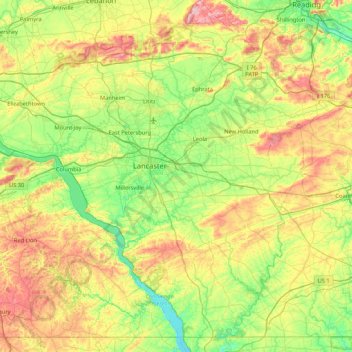
Nom : Carte topographique Lancaster County, altitude, relief.
Lieu : Lancaster County, Pennsylvania, United States (39.72110 -76.72196 40.31583 -75.87316)
Altitude moyenne : 158 m
Altitude minimum : 28 m
Altitude maximum : 412 m
Faire un don
Équipez-vous pour votre prochaine aventure :
En tant que Partenaire Amazon, ce site perçoit une commission sur les achats éligibles sans surcoût pour vous.
Autres cartes topographiques
Cliquez sur une carte pour visualiser sa topographie, son altitude et son relief.
Strawberry Mansion
United States > Pennsylvania > Philadelphia County > Philadelphia
Altitude moyenne : 31 m
East Texas
United States > Pennsylvania > Lehigh County > Lower Macungie Township
Altitude moyenne : 126 m
Faire un don
Équipez-vous pour votre prochaine aventure :
En tant que Partenaire Amazon, ce site perçoit une commission sur les achats éligibles sans surcoût pour vous.
Long Pond
United States > Pennsylvania > Monroe County > Tunkhannock Township
Long Pond is named after the unique wetland topography formed by the Tunkhannock Creek. Within the Long Pond community, public access lands are owned and protected by The Bethlehem Authority, Nature Conservancy, Wildlands Conservancy County of Monroe Open Space Program, , PA Game Commission and PA Department…
Altitude moyenne : 571 m
Breezewood
United States > Pennsylvania > Bedford County > East Providence Township
Altitude moyenne : 413 m
Albrightsville
United States > Pennsylvania > Carbon County > Kidder Township
Altitude moyenne : 498 m
Holland Heights
United States > Pennsylvania > Lancaster County > East Lampeter Township
Altitude moyenne : 101 m
Faire un don
Équipez-vous pour votre prochaine aventure :
En tant que Partenaire Amazon, ce site perçoit une commission sur les achats éligibles sans surcoût pour vous.
Lafayette Hill
United States > Pennsylvania > Montgomery County > Whitemarsh Township
Altitude moyenne : 59 m
Pymatuning State Park
United States > Pennsylvania > Crawford County > North Shenango Township
Altitude moyenne : 331 m
East Waterford
United States > Pennsylvania > Juniata County > Tuscarora Township
Altitude moyenne : 257 m
Faire un don
Équipez-vous pour votre prochaine aventure :
En tant que Partenaire Amazon, ce site perçoit une commission sur les achats éligibles sans surcoût pour vous.
Acme
United States > Pennsylvania > Westmoreland County > Mount Pleasant Township
Altitude moyenne : 585 m
Plymouth Meeting
United States > Pennsylvania > Montgomery County > Whitemarsh Township
Altitude moyenne : 54 m
Faire un don
Équipez-vous pour votre prochaine aventure :
En tant que Partenaire Amazon, ce site perçoit une commission sur les achats éligibles sans surcoût pour vous.
Dingmans Ferry
United States > Pennsylvania > Pike County > Delaware Township
Altitude moyenne : 192 m
Mount Nebo Park
United States > Pennsylvania > Monroe County > East Stroudsburg > Twin Falls
Altitude moyenne : 185 m
Faire un don
Équipez-vous pour votre prochaine aventure :
En tant que Partenaire Amazon, ce site perçoit une commission sur les achats éligibles sans surcoût pour vous.
Cowden
United States > Pennsylvania > Washington County > Cecil Township > Cecil
Altitude moyenne : 346 m
Keown Station
United States > Pennsylvania > Allegheny County > Ross Township
Altitude moyenne : 344 m
Faire un don
Équipez-vous pour votre prochaine aventure :
En tant que Partenaire Amazon, ce site perçoit une commission sur les achats éligibles sans surcoût pour vous.
Faire un don
Équipez-vous pour votre prochaine aventure :
En tant que Partenaire Amazon, ce site perçoit une commission sur les achats éligibles sans surcoût pour vous.
Faire un don
Équipez-vous pour votre prochaine aventure :
En tant que Partenaire Amazon, ce site perçoit une commission sur les achats éligibles sans surcoût pour vous.
New Enterprise
United States > Pennsylvania > Bedford County > South Woodbury Township
Altitude moyenne : 397 m
Blue Knob
United States > Pennsylvania > Bedford County > Pavia Township
Blue Knob (elevation 3,146 feet (959 m)) is a summit in the eastern United States with a broad dome that is the northernmost 3,000-footer in the Allegheny Mountains. It is the highest point in Bedford County, Pennsylvania.
Altitude moyenne : 792 m
Sinnemahoning
United States > Pennsylvania > Cameron County > Gibson Township
Altitude moyenne : 406 m
Saint Benedict
United States > Pennsylvania > Cambria County > West Carroll Township
Altitude moyenne : 582 m
Faire un don
Équipez-vous pour votre prochaine aventure :
En tant que Partenaire Amazon, ce site perçoit une commission sur les achats éligibles sans surcoût pour vous.
Fort Hunter
United States > Pennsylvania > Dauphin County > Middle Paxton Township
Altitude moyenne : 149 m
Green Village
United States > Pennsylvania > Franklin County > Greene Township
Altitude moyenne : 207 m
Faire un don
Équipez-vous pour votre prochaine aventure :
En tant que Partenaire Amazon, ce site perçoit une commission sur les achats éligibles sans surcoût pour vous.
Normalville
United States > Pennsylvania > Fayette County > Springfield Township
Altitude moyenne : 486 m
Arnold City
United States > Pennsylvania > Fayette County > Washington Township
Altitude moyenne : 303 m
Faire un don
Équipez-vous pour votre prochaine aventure :
En tant que Partenaire Amazon, ce site perçoit une commission sur les achats éligibles sans surcoût pour vous.
Three Tuns
United States > Pennsylvania > Montgomery County > Upper Dublin Township > Maple Glen
Altitude moyenne : 101 m
Hidden Valley
United States > Pennsylvania > Montgomery County > Upper Merion Township
Altitude moyenne : 47 m
Faire un don
Équipez-vous pour votre prochaine aventure :
En tant que Partenaire Amazon, ce site perçoit une commission sur les achats éligibles sans surcoût pour vous.
Strafford
United States > Pennsylvania > Chester County > Tredyffrin Township
Altitude moyenne : 133 m
West Pittsburg
United States > Pennsylvania > Lawrence County > Taylor Township
Altitude moyenne : 279 m
Faire un don
Équipez-vous pour votre prochaine aventure :
En tant que Partenaire Amazon, ce site perçoit une commission sur les achats éligibles sans surcoût pour vous.
Robinson
United States > Pennsylvania > Indiana County > West Wheatfield Township
Altitude moyenne : 397 m
Hazelton Mills
United States > Pennsylvania > McKean County > Bradford Township
Altitude moyenne : 598 m
Fogelsville
United States > Pennsylvania > Lehigh County > Upper Macungie Township
Altitude moyenne : 155 m
Faire un don
Équipez-vous pour votre prochaine aventure :
En tant que Partenaire Amazon, ce site perçoit une commission sur les achats éligibles sans surcoût pour vous.
Mount Bethel
United States > Pennsylvania > Northampton County > Upper Mount Bethel Township
Altitude moyenne : 156 m
Rosemount
United States > Pennsylvania > York County > Spring Garden Township
Altitude moyenne : 167 m
Faire un don
Équipez-vous pour votre prochaine aventure :
En tant que Partenaire Amazon, ce site perçoit une commission sur les achats éligibles sans surcoût pour vous.
Reservoir Heights
United States > Pennsylvania > Dauphin County > Upper Paxton Township
Altitude moyenne : 189 m
Skytop
United States > Pennsylvania > Monroe County > Barrett Township
Skytop is an unincorporated community in Barrett Township, Monroe County, Pennsylvania, United States. Located north of Mountainhome, it is accessible by local roads off Route 390. Its elevation is 1,562 feet (476 m), and it is located at 41°13′40″N 75°14′18″W / 41.22778°N 75.23833°W /…
Altitude moyenne : 469 m
Faire un don
Équipez-vous pour votre prochaine aventure :
En tant que Partenaire Amazon, ce site perçoit une commission sur les achats éligibles sans surcoût pour vous.
Ricketts Glen State Park
United States > Pennsylvania > Luzerne County > Fairmount Township
The state's original plans for the new park included building an inn, an 18-hole golf course and country club, and a winter sports complex for skiing, ice boating, and tobogganing, as well as a beach with bathing facilities, cabins, and a tent camping area. Only the last three were actually built, all south of…
Altitude moyenne : 588 m
Mount Cobb
United States > Pennsylvania > Lackawanna County > Jefferson Township
Altitude moyenne : 529 m
Pipersville
United States > Pennsylvania > Bucks County > Bedminster Township
Altitude moyenne : 125 m
Faire un don
Équipez-vous pour votre prochaine aventure :
En tant que Partenaire Amazon, ce site perçoit une commission sur les achats éligibles sans surcoût pour vous.
Pastorius Park
United States > Pennsylvania > Philadelphia County > Philadelphia
Altitude moyenne : 108 m
Danielsville
United States > Pennsylvania > Northampton County > Lehigh Township
Altitude moyenne : 254 m
Faire un don
Équipez-vous pour votre prochaine aventure :
En tant que Partenaire Amazon, ce site perçoit une commission sur les achats éligibles sans surcoût pour vous.
Blue Mountain
United States > Pennsylvania > Monroe County > Eldred Township
The ridge of Blue Mountain runs for 150 miles (240 km) through Pennsylvania, reaching an elevation of 2,270 feet (690 m) above sea level just north of the Pennsylvania Turnpike, near the borough of Newburg. Most of the ridgecrest, however, only reaches between 1,400 and 1,700 feet (430 and 520 m) in elevation.…
Altitude moyenne : 242 m
Park Place
United States > Pennsylvania > Schuylkill County > Mahanoy Township
Altitude moyenne : 515 m
Portlamd Waterfront Park
United States > Pennsylvania > Northampton County > Portland
Altitude moyenne : 118 m
Faire un don
Équipez-vous pour votre prochaine aventure :
En tant que Partenaire Amazon, ce site perçoit une commission sur les achats éligibles sans surcoût pour vous.
Stevens Point
United States > Pennsylvania > Susquehanna County > Harmony Township
Altitude moyenne : 434 m
Pendle Hill
United States > Pennsylvania > Delaware County > Nether Providence Township
Altitude moyenne : 61 m
Faire un don
Équipez-vous pour votre prochaine aventure :
En tant que Partenaire Amazon, ce site perçoit une commission sur les achats éligibles sans surcoût pour vous.
Longwood Gardens
United States > Pennsylvania > Chester County > East Marlborough Township
Altitude moyenne : 125 m
Nottingham County Park
United States > Pennsylvania > Chester County > West Nottingham Township
Altitude moyenne : 137 m
Faire un don
Équipez-vous pour votre prochaine aventure :
En tant que Partenaire Amazon, ce site perçoit une commission sur les achats éligibles sans surcoût pour vous.
Marble Hall
United States > Pennsylvania > Montgomery County > Whitemarsh Township
Altitude moyenne : 64 m
Circleville
United States > Pennsylvania > Westmoreland County > North Huntingdon Township
Altitude moyenne : 333 m
Faire un don
Équipez-vous pour votre prochaine aventure :
En tant que Partenaire Amazon, ce site perçoit une commission sur les achats éligibles sans surcoût pour vous.
Chadds Ford Township
United States > Pennsylvania > Delaware County > Chadds Ford Township
Altitude moyenne : 101 m
Reinholds
United States > Pennsylvania > Lancaster County > West Cocalico Township
Altitude moyenne : 159 m
Faire un don
Équipez-vous pour votre prochaine aventure :
En tant que Partenaire Amazon, ce site perçoit une commission sur les achats éligibles sans surcoût pour vous.
Langhorne Gardens
United States > Pennsylvania > Bucks County > Middletown Township
Altitude moyenne : 45 m
Faire un don
Équipez-vous pour votre prochaine aventure :
En tant que Partenaire Amazon, ce site perçoit une commission sur les achats éligibles sans surcoût pour vous.
Hanover Junction
United States > Pennsylvania > York County > North Codorus Township
Altitude moyenne : 187 m
Champion
United States > Pennsylvania > Allegheny County > North Fayette Township
Altitude moyenne : 360 m
Faire un don
Équipez-vous pour votre prochaine aventure :
En tant que Partenaire Amazon, ce site perçoit une commission sur les achats éligibles sans surcoût pour vous.