
Faire un don
Équipez-vous pour votre prochaine aventure :
En tant que Partenaire Amazon, ce site perçoit une commission sur les achats éligibles sans surcoût pour vous.
Carte topographique Spokane
Cliquez sur la carte pour afficher l’altitude.
Faire un don
Équipez-vous pour votre prochaine aventure :
En tant que Partenaire Amazon, ce site perçoit une commission sur les achats éligibles sans surcoût pour vous.
Spokane
Spokane (en anglais [ˌspoʊˈkæn]) est une ville de l'État de Washington, située à l'est de Seattle et au nord-est de Portland, aux États-Unis. C'est le siège du comté de Spokane. Située au bord de la rivière du même nom, la ville est installée sur le plateau du Columbia, à une altitude de 610 m, dans l'est de l'État dont elle est la seconde ville la plus peuplée. C'est aussi la quatrième ville du nord de la côte ouest. La population de l'aire urbaine est de 535 724 habitants, et si l'on inclut la région de Cœur d'Alene, séparée de Spokane par la frontière entre l'État de Washington et celui de l'Idaho, la population est portée à près de 600 000 habitants.
Faire un don
Équipez-vous pour votre prochaine aventure :
En tant que Partenaire Amazon, ce site perçoit une commission sur les achats éligibles sans surcoût pour vous.
À propos de cette carte
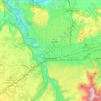
Nom : Carte topographique Spokane, altitude, relief.
Lieu : Spokane, Spokane County, Washington, États-Unis d'Amérique (47.58678 -117.60400 47.75880 -117.30386)
Altitude moyenne : 655 m
Altitude minimum : 470 m
Altitude maximum : 1.116 m
Faire un don
Équipez-vous pour votre prochaine aventure :
En tant que Partenaire Amazon, ce site perçoit une commission sur les achats éligibles sans surcoût pour vous.
Autres cartes topographiques
Cliquez sur une carte pour visualiser sa topographie, son altitude et son relief.