
Carte topographique South Dakota
Carte interactive
Cliquez sur la carte pour afficher l’altitude.
À propos de cette carte
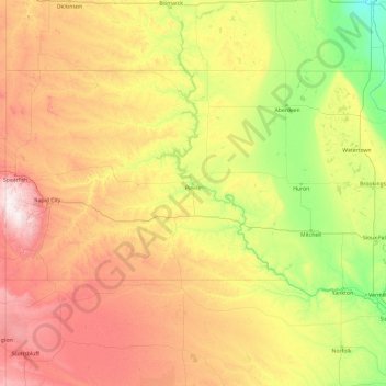
Nom : Carte topographique South Dakota, altitude, relief.
Lieu : South Dakota, United States (42.47989 -104.05776 45.94545 -96.43634)
Altitude moyenne : 717 m
Altitude minimum : 274 m
Altitude maximum : 2.166 m
Black Elk Peak, formerly named Harney Peak, with an elevation of 7,242 ft (2,207 m), is the state's highest point, while the shoreline of Big Stone Lake is the lowest, with an elevation of 966 ft (294 m). South Dakota is bordered to the north by North Dakota; to the south by Nebraska; to the east by Iowa and Minnesota; and to the west by Wyoming and Montana. The geographical center of the U.S. is 17 miles (27 km) west of Castle Rock in Butte County. The North American continental pole of inaccessibility is between Allen and Kyle, 1,024 mi (1,648 km) from the nearest coastline.
Autres cartes topographiques
Cliquez sur une carte pour visualiser sa topographie, son altitude et son relief.
Houston
United States > Texas > Harris County
Houston, Harris County, Texas, United States
Altitude moyenne : 25 m
Boulder
United States > Colorado > Boulder County
Boulder, Boulder County, Colorado, United States
Altitude moyenne : 1.785 m
Montgomery County
Montgomery County, Texas, United States
Altitude moyenne : 69 m
Los Angeles
Los Angeles, Los Angeles County, California, United States
Altitude moyenne : 241 m
The Woodlands
United States > Texas > Montgomery County
The Woodlands, Montgomery County, Texas, United States
Altitude moyenne : 47 m
Sequoia National Park
United States > California > Tulare County
Sequoia National Park, Tulare County, California, United States
Altitude moyenne : 2.515 m
Spokane
United States > Washington > Spokane County
Spokane, Spokane County, Washington, United States
Altitude moyenne : 655 m
Lancaster County
Lancaster County, Pennsylvania, United States
Altitude moyenne : 158 m
Hudson River
Hudson River, New Jersey, 12834:12871, United States
Altitude moyenne : 297 m
Fort Worth
United States > Texas > Tarrant County
Fort Worth, Tarrant County, Texas, United States
Altitude moyenne : 212 m
Brooklyn
United States > New York > New York
Brooklyn, Kings County, New York, United States
Altitude moyenne : 9 m
Tomball
United States > Texas > Harris County
Tomball, Harris County, Texas, 77375, United States
Altitude moyenne : 52 m
New Orleans
United States > Louisiana > Orleans Parish
New Orleans, Orleans Parish, Louisiana, United States
Altitude moyenne : 1 m
Sacramento
United States > California > Sacramento County
Sacramento, Sacramento County, California, United States
Altitude moyenne : 10 m
Queens County
United States > New York > New York
Queens County, New York, United States
Altitude moyenne : 11 m
Irvine
United States > California > Orange County
Irvine, Orange County, California, United States
Altitude moyenne : 66 m
Yosemite National Park
Yosemite National Park, California, United States
Altitude moyenne : 2.337 m