
Carte topographique Gryon
Carte interactive
Cliquez sur la carte pour afficher l’altitude.
À propos de cette carte
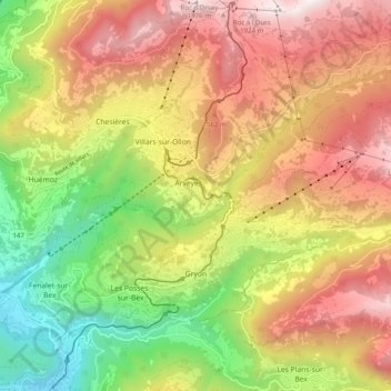
Nom : Carte topographique Gryon, altitude, relief.
Lieu : Gryon, District d'Aigle, Vaud, 1882, Switzerland (46.26606 7.05242 46.31035 7.15140)
Altitude moyenne : 1.240 m
Altitude minimum : 457 m
Altitude maximum : 2.014 m
The municipality is located in the Aigle district, on a narrow terrace at an elevation of 1,110 m (3,640 ft) between the Gryonne and Avançon canyons. To the east lie the hillside settlements of Les Chaux and La Barboleusaz (or Barboleuse). In the north are forests and the alpine pasture of Taveyanne. The western border with Bex was established in 1676.
Autres cartes topographiques
Cliquez sur une carte pour visualiser sa topographie, son altitude et son relief.
Drapel
Switzerland > Vaud > District d'Aigle > Aigle
Drapel, Aigle, District d'Aigle, Vaud, 1860, Switzerland
Altitude moyenne : 716 m
Vallée du Rhône
Switzerland > Vaud > District d'Aigle
Vallée du Rhône, District d'Aigle, Vaud, Switzerland
Altitude moyenne : 1.378 m
Leysin
Switzerland > Vaud > District d'Aigle
Leysin, District d'Aigle, Vaud, 1854, Switzerland
Altitude moyenne : 1.352 m
Noville
Switzerland > Vaud > District d'Aigle
Noville, District d'Aigle, Vaud, 1845, Switzerland
Altitude moyenne : 384 m
Glacier du Dar
Switzerland > Vaud > District d'Aigle > Ormont-Dessus
Glacier du Dar, Ormont-Dessus, District d'Aigle, Vaud, Switzerland
Altitude moyenne : 2.554 m
Chambon
Switzerland > Vaud > District d'Aigle > Roche (VD)
Chambon, Roche (VD), District d'Aigle, Vaud, 1852, Switzerland
Altitude moyenne : 485 m
Aigle
Switzerland > Vaud > District d'Aigle
Aigle, District d'Aigle, Vaud, 1860, Switzerland
Altitude moyenne : 647 m