
Carte topographique Leysin
Carte interactive
Cliquez sur la carte pour afficher l’altitude.
À propos de cette carte
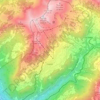
Nom : Carte topographique Leysin, altitude, relief.
Lieu : Leysin, District d'Aigle, Vaud, 1854, Switzerland (46.32070 6.97711 46.38518 7.04051)
Altitude moyenne : 1.352 m
Altitude minimum : 415 m
Altitude maximum : 2.299 m
The municipality is located in the Aigle district, on the right side of the Grande-Eau at the foot of the Tour d'Aï and the Tour de Mayen. The main village is located at an elevation of 1,260 m (4,130 ft). It consists of the village of Leysin and the hamlets of Veyges, Feydey, Aï, and Mayen.
Autres cartes topographiques
Cliquez sur une carte pour visualiser sa topographie, son altitude et son relief.
Drapel
Switzerland > Vaud > District d'Aigle > Aigle
Drapel, Aigle, District d'Aigle, Vaud, 1860, Switzerland
Altitude moyenne : 716 m
Vallée du Rhône
Switzerland > Vaud > District d'Aigle
Vallée du Rhône, District d'Aigle, Vaud, Switzerland
Altitude moyenne : 1.378 m
Gryon
Switzerland > Vaud > District d'Aigle
Gryon, District d'Aigle, Vaud, 1882, Switzerland
Altitude moyenne : 1.240 m
Noville
Switzerland > Vaud > District d'Aigle
Noville, District d'Aigle, Vaud, 1845, Switzerland
Altitude moyenne : 384 m
Glacier du Dar
Switzerland > Vaud > District d'Aigle > Ormont-Dessus
Glacier du Dar, Ormont-Dessus, District d'Aigle, Vaud, Switzerland
Altitude moyenne : 2.554 m
Chambon
Switzerland > Vaud > District d'Aigle > Roche (VD)
Chambon, Roche (VD), District d'Aigle, Vaud, 1852, Switzerland
Altitude moyenne : 485 m
Aigle
Switzerland > Vaud > District d'Aigle
Aigle, District d'Aigle, Vaud, 1860, Switzerland
Altitude moyenne : 647 m