
Carte topographique Vallée du Rhône
Carte interactive
Cliquez sur la carte pour afficher l’altitude.
À propos de cette carte
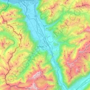
Nom : Carte topographique Vallée du Rhône, altitude, relief.
Lieu : Vallée du Rhône, District d'Aigle, Vaud, Switzerland (46.11847 6.85834 46.39681 7.06994)
Altitude moyenne : 1.378 m
Altitude minimum : 367 m
Altitude maximum : 3.247 m
Autres cartes topographiques
Cliquez sur une carte pour visualiser sa topographie, son altitude et son relief.
Drapel
Switzerland > Vaud > District d'Aigle > Aigle
Drapel, Aigle, District d'Aigle, Vaud, 1860, Switzerland
Altitude moyenne : 716 m
Gryon
Switzerland > Vaud > District d'Aigle
Gryon, District d'Aigle, Vaud, 1882, Switzerland
Altitude moyenne : 1.240 m
Leysin
Switzerland > Vaud > District d'Aigle
Leysin, District d'Aigle, Vaud, 1854, Switzerland
Altitude moyenne : 1.352 m
Noville
Switzerland > Vaud > District d'Aigle
Noville, District d'Aigle, Vaud, 1845, Switzerland
Altitude moyenne : 384 m
Glacier du Dar
Switzerland > Vaud > District d'Aigle > Ormont-Dessus
Glacier du Dar, Ormont-Dessus, District d'Aigle, Vaud, Switzerland
Altitude moyenne : 2.554 m
Chambon
Switzerland > Vaud > District d'Aigle > Roche (VD)
Chambon, Roche (VD), District d'Aigle, Vaud, 1852, Switzerland
Altitude moyenne : 485 m
Aigle
Switzerland > Vaud > District d'Aigle
Aigle, District d'Aigle, Vaud, 1860, Switzerland
Altitude moyenne : 647 m