
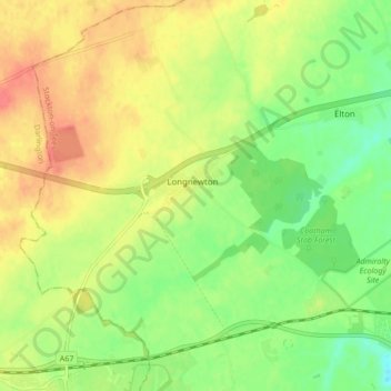
Carte topographique Longnewton
Carte interactive
Cliquez sur la carte pour afficher l’altitude.
À propos de cette carte
Nom : Carte topographique Longnewton, altitude, relief.
Altitude moyenne : 39 m
Altitude minimum : 12 m
Altitude maximum : 65 m
Autres cartes topographiques
Cliquez sur une carte pour visualiser sa topographie, son altitude et son relief.
Kingsmead
United Kingdom > England > Stockton-on-Tees > Eaglescliffe
Kingsmead, Eaglescliffe, Egglescliffe, Stockton-on-Tees, Tees Valley, England, TS16 0RR, United Kingdom
Altitude moyenne : 24 m
Preston-on-Tees
United Kingdom > England > Stockton-on-Tees
Preston-on-Tees, Stockton-on-Tees, Tees Valley, England, United Kingdom
Altitude moyenne : 20 m
Cowpen Bewley
United Kingdom > England > Stockton-on-Tees > Billingham
Cowpen Bewley, Billingham, Stockton-on-Tees, Tees Valley, England, TS23 4HR, United Kingdom
Altitude moyenne : 10 m
Seal Sands
United Kingdom > England > Stockton-on-Tees > Billingham
Seal Sands, Billingham, Stockton-on-Tees, Tees Valley, England, TS25 2DD, United Kingdom
Altitude moyenne : 2 m
Wynyard
United Kingdom > England > Stockton-on-Tees
Wynyard, Stockton-on-Tees, Tees Valley, England, United Kingdom
Altitude moyenne : 49 m
Stillington
United Kingdom > England > Stockton-on-Tees
Stillington, Stockton-on-Tees, Tees Valley, England, TS21 1JJ, United Kingdom
Altitude moyenne : 56 m
Stockton-on-Tees
United Kingdom > England > Stockton-on-Tees > Stockton-on-Tees
Stockton-on-Tees, North East England, England, United Kingdom
Altitude moyenne : 17 m
Elton
United Kingdom > England > Stockton-on-Tees
Elton, Stockton-on-Tees, Tees Valley, England, United Kingdom
Altitude moyenne : 31 m
Carlton
United Kingdom > England > Stockton-on-Tees
Carlton, Stockton-on-Tees, Tees Valley, England, United Kingdom
Altitude moyenne : 45 m
Six Fields Nature Reserve
United Kingdom > England > Stockton-on-Tees > Stockton-on-Tees
Six Fields Nature Reserve, Parkwood Drive, Hartburn Village, Stockton-on-Tees, Tees Valley, England, TS18 5DN, United Kingdom
Altitude moyenne : 18 m
Stockton-on-Tees
United Kingdom > England > Stockton-on-Tees
Stockton-on-Tees, Tees Valley, England, United Kingdom
Altitude moyenne : 19 m
Ingleby Barwick
United Kingdom > England > Stockton-on-Tees
Ingleby Barwick, Stockton-on-Tees, Tees Valley, England, United Kingdom
Altitude moyenne : 23 m
Aislaby
United Kingdom > England > Stockton-on-Tees
Aislaby, Stockton-on-Tees, Tees Valley, England, United Kingdom
Altitude moyenne : 27 m
Egglescliffe
United Kingdom > England > Stockton-on-Tees
Egglescliffe, Stockton-on-Tees, Tees Valley, England, United Kingdom
Altitude moyenne : 24 m
Norton
United Kingdom > England > Stockton-on-Tees > Norton
Norton, Stockton-on-Tees, North East England, England, United Kingdom
Altitude moyenne : 19 m
Billingham
United Kingdom > England > Stockton-on-Tees
Billingham, Stockton-on-Tees, Tees Valley, England, United Kingdom
Altitude moyenne : 21 m
Thorpe Thewles
United Kingdom > England > Stockton-on-Tees
Thorpe Thewles, Stockton-on-Tees, Tees Valley, England, TS21 3JZ, United Kingdom
Altitude moyenne : 48 m
Stockton-on-Tees
United Kingdom > England > Stockton-on-Tees > Stockton-on-Tees
Stockton-on-Tees, North East England, England, TS18 1A, United Kingdom
Altitude moyenne : 20 m
Kirklevington
United Kingdom > England > Stockton-on-Tees > Kirklevington
Kirklevington, Stockton-on-Tees, North East England, England, United Kingdom
Altitude moyenne : 46 m
Yarm
United Kingdom > England > Stockton-on-Tees
Yarm, Stockton-on-Tees, Tees Valley, England, United Kingdom
Altitude moyenne : 29 m
Wolviston
United Kingdom > England > Stockton-on-Tees
Wolviston, Stockton-on-Tees, Tees Valley, England, United Kingdom
Altitude moyenne : 27 m
Eaglescliffe
United Kingdom > England > Stockton-on-Tees
Eaglescliffe, Egglescliffe, Stockton-on-Tees, Tees Valley, England, TS16 0BJ, United Kingdom
Altitude moyenne : 23 m
Wynyard Village
United Kingdom > England > Stockton-on-Tees > Wynyard Village
Wynyard Village, Stockton-on-Tees, North East England, England, United Kingdom
Altitude moyenne : 60 m
Kirklevington
United Kingdom > England > Stockton-on-Tees
Kirklevington, Stockton-on-Tees, Tees Valley, England, United Kingdom
Altitude moyenne : 44 m