
Carte topographique Seal Sands
Carte interactive
Cliquez sur la carte pour afficher l’altitude.
À propos de cette carte
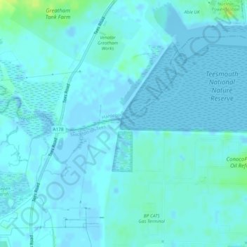
Nom : Carte topographique Seal Sands, altitude, relief.
Altitude moyenne : 2 m
Altitude minimum : -6 m
Altitude maximum : 15 m
Autres cartes topographiques
Cliquez sur une carte pour visualiser sa topographie, son altitude et son relief.
Cowpen Bewley
United Kingdom > England > Stockton-on-Tees > Billingham
Cowpen Bewley, Billingham, Stockton-on-Tees, Tees Valley, England, TS23 4HR, United Kingdom
Altitude moyenne : 10 m