
Carte topographique Gornera
Carte interactive
Cliquez sur la carte pour afficher l’altitude.
À propos de cette carte
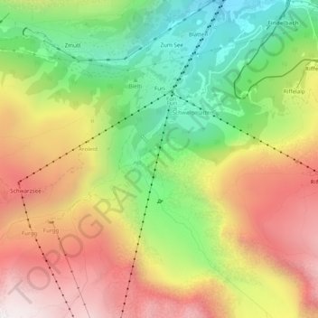
Nom : Carte topographique Gornera, altitude, relief.
Lieu : Gornera, Zermatt, Visp, Wallis, 3920, Switzerland (45.97788 7.72683 46.01117 7.74740)
Altitude moyenne : 2.226 m
Altitude minimum : 1.642 m
Altitude maximum : 2.843 m
Autres cartes topographiques
Cliquez sur une carte pour visualiser sa topographie, son altitude et son relief.
Gobba di Rollin
Switzerland > Wallis > Visp > Zermatt
Gobba di Rollin, Zermatt, Visp, Wallis, 3920, Switzerland
Altitude moyenne : 3.590 m
Matterhorn
Switzerland > Wallis > Visp > Zermatt
Matterhorn, Zermatt, Visp, Wallis, 3920, Switzerland
Altitude moyenne : 3.295 m
Monte Rosa
Switzerland > Wallis > Visp > Zermatt
Monte Rosa, Zermatt, Visp, Wallis, 3920, Switzerland
Altitude moyenne : 4.033 m
Blatten
Switzerland > Wallis > Visp > Zermatt
Blatten, Zermatt, Visp, Wallis, 3920, Switzerland
Altitude moyenne : 2.149 m