
Carte topographique Monte Rosa
Carte interactive
Cliquez sur la carte pour afficher l’altitude.
À propos de cette carte
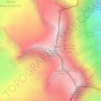
Nom : Carte topographique Monte Rosa, altitude, relief.
Lieu : Monte Rosa, Zermatt, Visp, Wallis, 3920, Switzerland (45.93686 7.86670 45.93696 7.86680)
Altitude moyenne : 4.033 m
Altitude minimum : 3.037 m
Altitude maximum : 4.619 m
The peak is distinguished by the name Dufourspitze (in German, lit. Dufour Peak; French: Pointe Dufour, Italian: Punta Dufour). This replaced the former name Höchste Spitze (English: Highest Peak) that was indicated on the Swiss maps before the Federal Council, on January 28, 1863, decided to rename the mountain in honor of Guillaume-Henri Dufour. Dufour was a Swiss engineer, topographer, co-founder of the Red Cross and army general who led the Sonderbund campaign. This decision followed the completion of the Dufour Map, a series of military topographical maps created under the command of Dufour.
Autres cartes topographiques
Cliquez sur une carte pour visualiser sa topographie, son altitude et son relief.
Gobba di Rollin
Switzerland > Wallis > Visp > Zermatt
Gobba di Rollin, Zermatt, Visp, Wallis, 3920, Switzerland
Altitude moyenne : 3.590 m
Matterhorn
Switzerland > Wallis > Visp > Zermatt
Matterhorn, Zermatt, Visp, Wallis, 3920, Switzerland
Altitude moyenne : 3.295 m
Gornera
Switzerland > Wallis > Visp > Zermatt
Gornera, Zermatt, Visp, Wallis, 3920, Switzerland
Altitude moyenne : 2.226 m
Blatten
Switzerland > Wallis > Visp > Zermatt
Blatten, Zermatt, Visp, Wallis, 3920, Switzerland
Altitude moyenne : 2.149 m