
Faire un don
Équipez-vous pour votre prochaine aventure :
En tant que Partenaire Amazon, ce site perçoit une commission sur les achats éligibles sans surcoût pour vous.
Carte topographique Trinity County
Cliquez sur la carte pour afficher l’altitude.
Faire un don
Équipez-vous pour votre prochaine aventure :
En tant que Partenaire Amazon, ce site perçoit une commission sur les achats éligibles sans surcoût pour vous.
Trinity County
The county hosts many visitors, especially during summer months, for camping, backpacking, boating on the lakes, rafting/kayaking on the rivers, hunting, and fishing. The summers tend to be clear, sunny, warm, and very dry, with little rain from June to September except for some mountain thunderstorms in the highest elevations. Summer days in the populated areas of the county range from 90 to 97 degrees, and summer nights range from 45 to 55. Winter days range from 40 to 50, and nights range from 25 to 35. The winters tend to have copious precipitation, increasing with elevation and falling mostly as rain under 1000m/3300 ft in the valley bottoms, and mostly as snow over 1000m/3300 ft on the mountainsides. December, January, and February are the wettest. The precipitation ranges from 30 to 35 inches at low elevations isolated from coastal influence, such as Big Bar, Hayfork, and Weaverville, up to 55 or 60 inches at high elevations, on the coastal side of South Fork Mountain, or where gaps in the mountain allow for precipitation to get through. Examples of this last phenomenon include Salyer and Forest Glen. Kalmia Lake, at nearly 7500 feet in the Canyon Creek area of the Trinity Alps, is reputed to be the snowiest place in California, outpacing Lake Helen in Mount Lassen National Park, which receives 600-700 inches of snow each winter. Average snowfall in the populated parts of the county ranges from 0-5 inches in the lower Trinity Valley to at least 100 inches in places above 4000 feet, such as Indian Valley west of Hayfork.
Faire un don
Équipez-vous pour votre prochaine aventure :
En tant que Partenaire Amazon, ce site perçoit une commission sur les achats éligibles sans surcoût pour vous.
À propos de cette carte
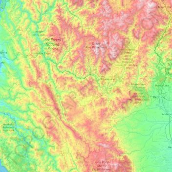
Nom : Carte topographique Trinity County, altitude, relief.
Lieu : Trinity County, California, United States (39.97696 -123.62377 41.36855 -122.44580)
Altitude moyenne : 868 m
Altitude minimum : 0 m
Altitude maximum : 2.663 m
Faire un don
Équipez-vous pour votre prochaine aventure :
En tant que Partenaire Amazon, ce site perçoit une commission sur les achats éligibles sans surcoût pour vous.
Autres cartes topographiques
Cliquez sur une carte pour visualiser sa topographie, son altitude et son relief.
Faire un don
Équipez-vous pour votre prochaine aventure :
En tant que Partenaire Amazon, ce site perçoit une commission sur les achats éligibles sans surcoût pour vous.
Brawley
United States > California > Imperial County
Brawley is located in the Colorado Desert and Lower Colorado River Valley regions. The city's elevation, like other Imperial Valley towns, is below sea level.
Altitude moyenne : -44 m
Faire un don
Équipez-vous pour votre prochaine aventure :
En tant que Partenaire Amazon, ce site perçoit une commission sur les achats éligibles sans surcoût pour vous.
Bodie
United States > California > Mono County
Bodie (/ˈboʊdiː/ BOH-dee) is a ghost town in the Bodie Hills east of the Sierra Nevada mountain range in Mono County, California, United States. It is about 75 miles (121 km) southeast of Lake Tahoe, and 12 mi (19 km) east-southeast of Bridgeport, at an elevation of 8,379 feet (2554 m). Bodie became a boom…
Altitude moyenne : 2.627 m
Faire un don
Équipez-vous pour votre prochaine aventure :
En tant que Partenaire Amazon, ce site perçoit une commission sur les achats éligibles sans surcoût pour vous.
Sierra Vista Open Space Preserve
United States > California > Santa Clara County > San Jose
Altitude moyenne : 484 m
Mountain Center
United States > California > Riverside County
It lies centered on the junction of State Route 74 and State Route 243 in the southern division of San Bernardino National Forest. Mountain Center lies just north of Lake Hemet, midway between Hemet and Palm Desert, just south of the town of Idyllwild, and it is southeast of the city of Riverside, the county…
Altitude moyenne : 1.476 m
Faire un don
Équipez-vous pour votre prochaine aventure :
En tant que Partenaire Amazon, ce site perçoit une commission sur les achats éligibles sans surcoût pour vous.
Faire un don
Équipez-vous pour votre prochaine aventure :
En tant que Partenaire Amazon, ce site perçoit une commission sur les achats éligibles sans surcoût pour vous.
Yosemite Valley
United States > California > Mariposa County > Yosemite Village
Altitude moyenne : 2.016 m
Faire un don
Équipez-vous pour votre prochaine aventure :
En tant que Partenaire Amazon, ce site perçoit une commission sur les achats éligibles sans surcoût pour vous.
Fort Ross
United States > California > Sonoma County > Fort Ross
The Native Alaskan Village site was the subject of an investigation into its spatial organization, seeing “topographic mapping of surface features, systematic surface collection and generation of artifact distribution maps, and geophysical investigations involving both magnetometer and soil resistance…
Altitude moyenne : 68 m
Half Dome
United States > California > Mariposa County
The Half Dome Cable Route hike runs from the valley floor to the top of the dome in 8.2 mi (13 km) (via the Mist Trail), with 4,800 ft (1,460 m) of elevation gain. The length and difficulty of the trail used to keep it less crowded than other park trails, but in recent years the trail traffic has grown to as…
Altitude moyenne : 1.887 m
Faire un don
Équipez-vous pour votre prochaine aventure :
En tant que Partenaire Amazon, ce site perçoit une commission sur les achats éligibles sans surcoût pour vous.
Salton Sea
United States > California > CAL Fire San Diego Unit
The Gulf of California would extend as far north as the city of Indio, were it not for the delta created by the Colorado River. Over three million years, through all of the Pleistocene, the river's delta expanded until it cut off the northern part of the gulf. Since then, the Colorado River has alternated…
Altitude moyenne : 8 m
Faire un don
Équipez-vous pour votre prochaine aventure :
En tant que Partenaire Amazon, ce site perçoit une commission sur les achats éligibles sans surcoût pour vous.
Hollywood Reservoir
United States > California > Los Angeles County > Los Angeles
Altitude moyenne : 252 m
San Diego
United States > California > San Diego County > San Diego
The climate in San Diego, like most of Southern California, often varies significantly over short geographical distances, resulting in microclimates. In San Diego, this is mostly because of the city's topography (the Bay, and the numerous hills, mountains, and canyons). Frequently, particularly during the "May…
Altitude moyenne : 57 m
Faire un don
Équipez-vous pour votre prochaine aventure :
En tant que Partenaire Amazon, ce site perçoit une commission sur les achats éligibles sans surcoût pour vous.
Redding
United States > California > Shasta County > Redding
The elevation in Redding is 495 feet (151 meters) on average, whereas anywhere to the north, east, or west of downtown ranges between 550 feet (170 m) and 800 feet (240 m) feet. Southern portions range between 400 feet (120 m) and 500 feet (150 m).
Altitude moyenne : 312 m
Argyle Number 2 31-030 Dam
United States > California > Contra Costa County > El Sobrante
Altitude moyenne : 78 m
Faire un don
Équipez-vous pour votre prochaine aventure :
En tant que Partenaire Amazon, ce site perçoit une commission sur les achats éligibles sans surcoût pour vous.
Arrowhead
United States > California > San Bernardino County > San Bernardino > Arrowhead
Altitude moyenne : 383 m
Faire un don
Équipez-vous pour votre prochaine aventure :
En tant que Partenaire Amazon, ce site perçoit une commission sur les achats éligibles sans surcoût pour vous.