
Faire un don
Équipez-vous pour votre prochaine aventure :
En tant que Partenaire Amazon, ce site perçoit une commission sur les achats éligibles sans surcoût pour vous.
Carte topographique Mirabel Park
Cliquez sur la carte pour afficher l’altitude.
Faire un don
Équipez-vous pour votre prochaine aventure :
En tant que Partenaire Amazon, ce site perçoit une commission sur les achats éligibles sans surcoût pour vous.
À propos de cette carte
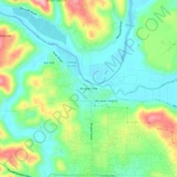
Nom : Carte topographique Mirabel Park, altitude, relief.
Altitude moyenne : 58 m
Altitude minimum : 8 m
Altitude maximum : 160 m
Faire un don
Équipez-vous pour votre prochaine aventure :
En tant que Partenaire Amazon, ce site perçoit une commission sur les achats éligibles sans surcoût pour vous.
Autres cartes topographiques
Cliquez sur une carte pour visualiser sa topographie, son altitude et son relief.
Fort Ross
United States > California > Sonoma County > Fort Ross
The Native Alaskan Village site was the subject of an investigation into its spatial organization, seeing “topographic mapping of surface features, systematic surface collection and generation of artifact distribution maps, and geophysical investigations involving both magnetometer and soil resistance…
Altitude moyenne : 68 m