
Carte topographique Realp
Carte interactive
Cliquez sur la carte pour afficher l’altitude.
À propos de cette carte
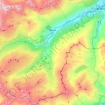
Nom : Carte topographique Realp, altitude, relief.
Lieu : Realp, Korporation Ursern, Uri, 6491, Switzerland (46.52763 8.40614 46.62727 8.53926)
Altitude moyenne : 2.282 m
Altitude minimum : 1.450 m
Altitude maximum : 3.267 m
Autres cartes topographiques
Cliquez sur une carte pour visualiser sa topographie, son altitude et son relief.
Hospental
Switzerland > Uri > Korporation Ursern
Hospental, Korporation Ursern, Uri, 6493, Switzerland
Altitude moyenne : 2.144 m
Oberalppass
Switzerland > Uri > Korporation Ursern > Andermatt
Oberalppass, Andermatt, Korporation Ursern, Uri, 6490, Switzerland
Altitude moyenne : 2.219 m
Rhonegletscher
Switzerland > Uri > Korporation Ursern > Realp
Rhonegletscher, Realp, Korporation Ursern, Oberland administrative region, Uri, 6491, Switzerland
Altitude moyenne : 2.802 m
Andermatt
Switzerland > Uri > Korporation Ursern
Andermatt, Korporation Ursern, Uri, 6490, Switzerland
Altitude moyenne : 2.127 m