
Carte topographique Andermatt
Carte interactive
Cliquez sur la carte pour afficher l’altitude.
Andermatt
Selon l'Office fédéral de la statistique, Andermatt a une superficie de 62,20 km2. Seuls 2 % de la commune est constructible. Les surfaces agricoles constituent 41 % de la superficie totale. Du fait de l'altitude élevée, seuls 5,5 % de la commune est boisé. Le reste (52 %) est constitué de zones non productives : eaux, montagnes.
À propos de cette carte
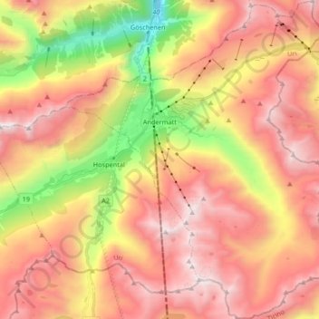
Nom : Carte topographique Andermatt, altitude, relief.
Lieu : Andermatt, Korporation Ursern, Uri, 6490, Suisse (46.56410 8.54654 46.67706 8.68192)
Altitude moyenne : 2.127 m
Altitude minimum : 1.023 m
Altitude maximum : 2.972 m
Autres cartes topographiques
Cliquez sur une carte pour visualiser sa topographie, son altitude et son relief.
Col de l'Oberalp
Suisse > Uri > Korporation Ursern > Andermatt
Le col de l'Oberalp (en romanche Alpsu ou Cuolm d'Ursera, en allemand Oberalppass) est situé dans les Alpes suisses, entre les Alpes glaronaises et les Alpes lépontines, à 2 044 mètres d'altitude. Il permet de relier la vallée du Rhin antérieur à Andermatt.
Altitude moyenne : 2.219 m