
Carte topographique Uintah County
Carte interactive
Cliquez sur la carte pour afficher l’altitude.
À propos de cette carte
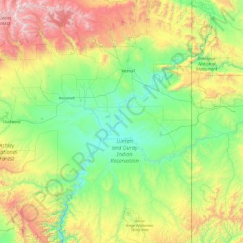
Nom : Carte topographique Uintah County, altitude, relief.
Lieu : Uintah County, Utah, VS (39.46174 -110.04490 40.85818 -109.04789)
Altitude moyenne : 2.055 m
Altitude minimum : 1.394 m
Altitude maximum : 4.098 m
Autres cartes topographiques
Cliquez sur une carte pour visualiser sa topographie, son altitude et son relief.
Bryce Canyon National Park
Bryce Canyon National Park, Under the Rim Trail, Garfield County, Utah, VS
Altitude moyenne : 2.259 m
Ashley National Forest
Ashley National Forest, Duchesne County, Utah, VS
Altitude moyenne : 2.248 m
Capitol Reef National Park
Capitol Reef National Park, Notom To Oak Creek Road, Garfield County, Utah, VS
Altitude moyenne : 1.963 m
Fishlake National Forest
Fishlake National Forest, US Forest Service Road 1782, Garfield County, Utah, VS
Altitude moyenne : 2.075 m
Canyonlands National Park
Canyonlands National Park, Wayne County, Utah, VS
Altitude moyenne : 1.640 m