Géolocaliser

Carte topographique Bryce Canyon National Park

Carte interactive

Cliquez sur la carte pour afficher l’altitude.

À propos de cette carte

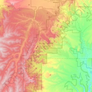
Nom : Carte topographique Bryce Canyon National Park, altitude, relief.

Lieu : Bryce Canyon National Park, Under the Rim Trail, Garfield County, Utah, VS (37.44205 -112.27400 37.69927 -112.08325)

Altitude moyenne : 2.259 m

Altitude minimum : 1.640 m

Altitude maximum : 2.902 m

Autres cartes topographiques

Cliquez sur une carte pour visualiser sa topographie, son altitude et son relief.

Kanab

VS > Utah > Kanab

Kanab, Kane County, Utah, VS

Altitude moyenne : 1.563 m

Snyder

VS > Utah > Snyder

Snyder, Salt Lake County, Utah, 84006, VS

Altitude moyenne : 1.626 m

Kings Peak

VS > Utah

Kings Peak, Duchesne County, Utah, VS

Altitude moyenne : 3.741 m

Ashley National Forest

VS > Utah

Ashley National Forest, Duchesne County, Utah, VS

Altitude moyenne : 2.248 m

Marble Canyon

VS > Utah

Marble Canyon, Grand County, Utah, VS

Altitude moyenne : 1.696 m

Delano Peak

VS > Utah

Delano Peak, Piute County, Utah, VS

Altitude moyenne : 3.447 m

Capitol Reef National Park

VS > Utah

Capitol Reef National Park, Notom To Oak Creek Road, Garfield County, Utah, VS

Altitude moyenne : 1.963 m

Park City

VS > Utah > Park City

Park City, Utah, VS

Altitude moyenne : 2.290 m

Uintah County

VS > Utah

Uintah County, Utah, VS

Altitude moyenne : 2.055 m

Mount Ellsworth

VS > Utah

Mount Ellsworth, Garfield County, Utah, VS

Altitude moyenne : 2.111 m

Price

VS > Utah > Price

Price, Carbon County, Utah, 84501, VS

Altitude moyenne : 1.711 m

Vernal

VS > Utah > Vernal

Vernal, Uintah County, Utah, 84078, VS

Altitude moyenne : 1.625 m

Fishlake National Forest

VS > Utah

Fishlake National Forest, US Forest Service Road 1782, Garfield County, Utah, VS

Altitude moyenne : 2.075 m

Canyonlands National Park

VS > Utah

Canyonlands National Park, Wayne County, Utah, VS

Altitude moyenne : 1.640 m