
Faire un don
Équipez-vous pour votre prochaine aventure :
En tant que Partenaire Amazon, ce site perçoit une commission sur les achats éligibles sans surcoût pour vous.
Carte topographique Tiber
Cliquez sur la carte pour afficher l’altitude.
Faire un don
Équipez-vous pour votre prochaine aventure :
En tant que Partenaire Amazon, ce site perçoit une commission sur les achats éligibles sans surcoût pour vous.
À propos de cette carte
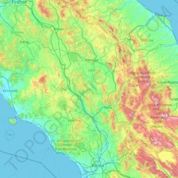
Nom : Carte topographique Tiber, altitude, relief.
Lieu : Tiber, Italy (41.74515 12.02487 43.78924 12.63874)
Altitude moyenne : 418 m
Altitude minimum : -5 m
Altitude maximum : 2.720 m
Faire un don
Équipez-vous pour votre prochaine aventure :
En tant que Partenaire Amazon, ce site perçoit une commission sur les achats éligibles sans surcoût pour vous.
Autres cartes topographiques
Cliquez sur une carte pour visualiser sa topographie, son altitude et son relief.
Rome
Italy > Lazio > Roma Capitale
Although the city centre is about 24 km (15 mi) inland from the Tyrrhenian Sea, the city territory extends to the shore, where the south-western district of Ostia is located. The altitude of the central part of Rome ranges from 13 m (43 ft) above sea level (at the base of the Pantheon) to 139 m (456 ft) above…
Altitude moyenne : 78 m
Passo dello Stelvio
Italy > Trentino-Alto Adige/Südtirol > South Tyrol > Stilfs - Stelvio
The Stelvio Pass (Italian: Passo dello Stelvio [passo ˈdello ˈstɛlvjo], Giogo dello Stelvio [dʒɔgo ˈdello ˈstɛlvjo]; German: Stilfser Joch; [ˈʃtɪlfsɐ jɔx]) is a mountain pass in northern Italy bordering Switzerland at an elevation of 2,757 m (9,045 ft) above sea level. It is the highest paved…
Altitude moyenne : 2.724 m
Faire un don
Équipez-vous pour votre prochaine aventure :
En tant que Partenaire Amazon, ce site perçoit une commission sur les achats éligibles sans surcoût pour vous.
Mount Etna
Italy > Sicily > Maletto > Adrano
During the first 1500 years AD, many eruptions went unrecorded (or records have been lost); among the more significant are: (1) an eruption in about 1030 AD near Monte Ilice on the lower southeast flank, which produced a lava flow that travelled about 10 km, reaching the sea north of Acireale; the villages of…
Altitude moyenne : 1.157 m
Faire un don
Équipez-vous pour votre prochaine aventure :
En tant que Partenaire Amazon, ce site perçoit une commission sur les achats éligibles sans surcoût pour vous.
Dolina Seghina / Šeginov Dol
Italy > Friuli-Venezia Giulia > Trieste > Gabrovizza / Gabrovec > Stazione di Prosecco / Proseška Postaja
Altitude moyenne : 249 m
Seiser Alm-Gruppe - Gruppo Mont de Sëuc - Gruppo dell'Alpe di Siusi
Italy > Trentino – Alto Adige/Südtirol > South Tyrol > Kastelruth - Castelrotto
Seiser Alm (Italian: Alpe di Siusi, Ladin: Mont Sëuc) is a Dolomite plateau and the largest high-elevation Alpine meadow (German: Alm) in Europe. Located in Italy's South Tyrol province in the Dolomites mountain range, it is a major tourist attraction, notably for skiing and hiking.
Altitude moyenne : 1.466 m
Faire un don
Équipez-vous pour votre prochaine aventure :
En tant que Partenaire Amazon, ce site perçoit une commission sur les achats éligibles sans surcoût pour vous.
Faire un don
Équipez-vous pour votre prochaine aventure :
En tant que Partenaire Amazon, ce site perçoit une commission sur les achats éligibles sans surcoût pour vous.
Meransen - Maranza
Italy > Trentino – Alto Adige/Südtirol > South Tyrol
Meransen (Italian: Maranza) is a village in South Tyrol, Italy, in the Mühlbach municipality between Pustertal and Eisacktal. It located on the slopes of the Gitschberg mountain at an altitude of 1,414 m (4,639 ft).
Altitude moyenne : 1.279 m
Pila
There are more than 24 pistes (>70 km total length), including 4 blue runs, 29 red runs and 4 black runs, with a pipe zone and a slopestyle zone. There is one cable car, 3 gondolas, 8 chairlifts and 5 conveyors. The resort itself is at 1,814 metres altitude, while the highest skiing can be done at 2,700m.
Altitude moyenne : 1.817 m
Karer See - Lago di Carezza
Italy > Trentino-Alto Adige/Südtirol > South Tyrol > Karersee - Carezza
The lake is located in the western Dolomites on the edge of the Latemarwald, just 20 kilometers southeast of Bolzano at 1520 m altitude in the municipality Welschnofen. The nearest settlement is Carezza. The roughly 300 m long and 140 m wide stretch of water is fed by underground springs from the Latemar…
Altitude moyenne : 1.606 m
Faire un don
Équipez-vous pour votre prochaine aventure :
En tant que Partenaire Amazon, ce site perçoit une commission sur les achats éligibles sans surcoût pour vous.
Campo Imperatore
Italy > Abruzzo > L'Aquila > L'Aquila
The plateau's altitude ranges from 1,500 to 1,900 meters. It covers an expanse of approximately 80 km². Campo Imperatore is home to one of Italy's oldest alpine ski resorts. Located on the plateau's western edge, the resort began commercial operation in the 1920s and continues to thrive as a ski resort to…
Altitude moyenne : 2.056 m
Faire un don
Équipez-vous pour votre prochaine aventure :
En tant que Partenaire Amazon, ce site perçoit une commission sur les achats éligibles sans surcoût pour vous.
Oberglaning - Cologna di Sopra
Italy > Trentino-Alto Adige/Südtirol > South Tyrol > Jenesien - San Genesio Atesino
Altitude moyenne : 844 m
Colle Fauniera
Italy > Piedmont > Cuneo > Demonte
The Colle Fauniera is a mountain pass in the Cottian Alps, Piedmont, northern Italy, located at 2,480+ m elevation.
Altitude moyenne : 2.315 m
Faire un don
Équipez-vous pour votre prochaine aventure :
En tant que Partenaire Amazon, ce site perçoit une commission sur les achats éligibles sans surcoût pour vous.
Fiume Brenta
Italy > Trentino-Alto Adige/Südtirol > Provincia di Trento > Caldonazzo > Brenta
Altitude moyenne : 470 m
Klobenstein - Collalbo
Italy > Trentino – Alto Adige/Südtirol > South Tyrol > Ritten - Renon
Altitude moyenne : 1.135 m
Faire un don
Équipez-vous pour votre prochaine aventure :
En tant que Partenaire Amazon, ce site perçoit une commission sur les achats éligibles sans surcoût pour vous.
Faire un don
Équipez-vous pour votre prochaine aventure :
En tant que Partenaire Amazon, ce site perçoit une commission sur les achats éligibles sans surcoût pour vous.
Gisse
Italy > Trentino – Alto Adige/Südtirol > South Tyrol > Ahrntal - Valle Aurina
Altitude moyenne : 1.368 m
St. Zyprian - San Cipriano
Italy > Trentino-Alto Adige/Südtirol > South Tyrol
Altitude moyenne : 1.454 m
Faire un don
Équipez-vous pour votre prochaine aventure :
En tant que Partenaire Amazon, ce site perçoit une commission sur les achats éligibles sans surcoût pour vous.
Faire un don
Équipez-vous pour votre prochaine aventure :
En tant que Partenaire Amazon, ce site perçoit une commission sur les achats éligibles sans surcoût pour vous.
Faire un don
Équipez-vous pour votre prochaine aventure :
En tant que Partenaire Amazon, ce site perçoit une commission sur les achats éligibles sans surcoût pour vous.
Faire un don
Équipez-vous pour votre prochaine aventure :
En tant que Partenaire Amazon, ce site perçoit une commission sur les achats éligibles sans surcoût pour vous.
Faire un don
Équipez-vous pour votre prochaine aventure :
En tant que Partenaire Amazon, ce site perçoit une commission sur les achats éligibles sans surcoût pour vous.
Sardagna
Italy > Trentino – Alto Adige/Südtirol > Provincia di Trento > Trento
Altitude moyenne : 579 m
Pieve di Cadore
Italy > Veneto > Belluno > Pieve di Cadore > Pieve di Cadore
Altitude moyenne : 1.116 m
Bussana Vecchia
Italy > Liguria > Imperia > Sanremo > Poggio di Sanremo > Bussana Vecchia
Altitude moyenne : 114 m
Kronplatz - Plan de Corones
Italy > Trentino-Alto Adige/Südtirol > South Tyrol > Bruneck - Brunico
The Kronplatz (Ladin and Italian: Plan de Corones) is a mountain of the Dolomites in South Tyrol, northern Italy, with a summit elevation of 2,275 metres (7,464 ft) above sea level.
Altitude moyenne : 1.953 m
Faire un don
Équipez-vous pour votre prochaine aventure :
En tant que Partenaire Amazon, ce site perçoit une commission sur les achats éligibles sans surcoût pour vous.
Faire un don
Équipez-vous pour votre prochaine aventure :
En tant que Partenaire Amazon, ce site perçoit une commission sur les achats éligibles sans surcoût pour vous.
Moline
Italy > Trentino-Alto Adige/Südtirol > Provincia di Trento > San Lorenzo in Banale
Altitude moyenne : 952 m
Piz Boè
Italy > Trentino – Alto Adige/Südtirol > South Tyrol > Corvara in Badia - Corvara
Piz Boè is the highest mountain of the Sella group, a mountain range in the Dolomites, Italy. It has an elevation of 3,152 metres (10,341 ft).
Altitude moyenne : 2.664 m
Faire un don
Équipez-vous pour votre prochaine aventure :
En tant que Partenaire Amazon, ce site perçoit une commission sur les achats éligibles sans surcoût pour vous.
Monte Solaro
Italy > Campania > Naples > Anacapri
Monte Solaro is a mountain on the island of Capri in Campania, Italy. With an elevation of 589 m, its peak is the highest point of Capri.
Altitude moyenne : 155 m
Faire un don
Équipez-vous pour votre prochaine aventure :
En tant que Partenaire Amazon, ce site perçoit une commission sur les achats éligibles sans surcoût pour vous.
Faire un don
Équipez-vous pour votre prochaine aventure :
En tant que Partenaire Amazon, ce site perçoit une commission sur les achats éligibles sans surcoût pour vous.
Faire un don
Équipez-vous pour votre prochaine aventure :
En tant que Partenaire Amazon, ce site perçoit une commission sur les achats éligibles sans surcoût pour vous.
Mangart Saddle
Italy > Friuli – Venezia Giulia > Udine > Tarvisio
Mangart Saddle or the Mangart Pass (Slovene: Mangartsko sedlo or Mangrtsko sedlo) is a mountain saddle in the Julian Alps in northwestern Slovenia. It has an elevation of 2,072 metres (6,798 ft). It is the most common starting point for the ascent of Mt. Mangart (2,679 m or 8,789 ft). The Mangart Road…
Altitude moyenne : 1.780 m
Faire un don
Équipez-vous pour votre prochaine aventure :
En tant que Partenaire Amazon, ce site perçoit une commission sur les achats éligibles sans surcoût pour vous.
Faire un don
Équipez-vous pour votre prochaine aventure :
En tant que Partenaire Amazon, ce site perçoit une commission sur les achats éligibles sans surcoût pour vous.
Ghiacciaio del Belvedere
Italy > Piedmont > Verbano-Cusio-Ossola > Macugnaga
Altitude moyenne : 2.211 m
Faire un don
Équipez-vous pour votre prochaine aventure :
En tant que Partenaire Amazon, ce site perçoit une commission sur les achats éligibles sans surcoût pour vous.
Gnates
Italy > Trentino – Alto Adige/Südtirol > South Tyrol > La Val - Wengen - La Valle
Altitude moyenne : 1.504 m
Faire un don
Équipez-vous pour votre prochaine aventure :
En tant que Partenaire Amazon, ce site perçoit une commission sur les achats éligibles sans surcoût pour vous.
Faire un don
Équipez-vous pour votre prochaine aventure :
En tant que Partenaire Amazon, ce site perçoit une commission sur les achats éligibles sans surcoût pour vous.