
Faire un don
Équipez-vous pour votre prochaine aventure :
En tant que Partenaire Amazon, ce site perçoit une commission sur les achats éligibles sans surcoût pour vous.
Carte topographique Passo dello Stelvio
Cliquez sur la carte pour afficher l’altitude.
Faire un don
Équipez-vous pour votre prochaine aventure :
En tant que Partenaire Amazon, ce site perçoit une commission sur les achats éligibles sans surcoût pour vous.
Passo dello Stelvio
The Stelvio Pass (Italian: Passo dello Stelvio [passo ˈdello ˈstɛlvjo], Giogo dello Stelvio [dʒɔgo ˈdello ˈstɛlvjo]; German: Stilfser Joch; [ˈʃtɪlfsɐ jɔx]) is a mountain pass in northern Italy bordering Switzerland at an elevation of 2,757 m (9,045 ft) above sea level. It is the highest paved mountain pass in the Eastern Alps, and the second highest in the Alps, 7 m (23 ft) below France's Col de l'Iseran (2,764 m (9,068 ft)).
Faire un don
Équipez-vous pour votre prochaine aventure :
En tant que Partenaire Amazon, ce site perçoit une commission sur les achats éligibles sans surcoût pour vous.
À propos de cette carte
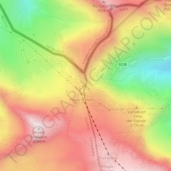
Nom : Carte topographique Passo dello Stelvio, altitude, relief.
Altitude moyenne : 2.724 m
Altitude minimum : 2.261 m
Altitude maximum : 3.075 m
Faire un don
Équipez-vous pour votre prochaine aventure :
En tant que Partenaire Amazon, ce site perçoit une commission sur les achats éligibles sans surcoût pour vous.