
Faire un don
Équipez-vous pour votre prochaine aventure :
En tant que Partenaire Amazon, ce site perçoit une commission sur les achats éligibles sans surcoût pour vous.
Carte topographique Clever
Cliquez sur la carte pour afficher l’altitude.
Faire un don
Équipez-vous pour votre prochaine aventure :
En tant que Partenaire Amazon, ce site perçoit une commission sur les achats éligibles sans surcoût pour vous.
Clever
Clever is located on the Springfield Plateau of the Missouri Ozarks, 14.5 miles (23.3 km) southwest of Springfield at an elevation of 1,398 feet (426 m). The town lies in the western panhandle of Christian County, just south of Missouri Highway 14 between Nixa and Billings. The town of Republic and the Wilson's Creek National Battlefield are approximately six miles to the north and northeast.
Faire un don
Équipez-vous pour votre prochaine aventure :
En tant que Partenaire Amazon, ce site perçoit une commission sur les achats éligibles sans surcoût pour vous.
À propos de cette carte
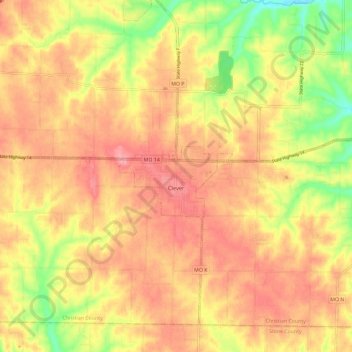
Nom : Carte topographique Clever, altitude, relief.
Lieu : Clever, Christian County, Missouri, United States (36.99394 -93.52779 37.07283 -93.41096)
Altitude moyenne : 397 m
Altitude minimum : 338 m
Altitude maximum : 433 m
Faire un don
Équipez-vous pour votre prochaine aventure :
En tant que Partenaire Amazon, ce site perçoit une commission sur les achats éligibles sans surcoût pour vous.
Autres cartes topographiques
Cliquez sur une carte pour visualiser sa topographie, son altitude et son relief.