
Faire un don
Équipez-vous pour votre prochaine aventure :
En tant que Partenaire Amazon, ce site perçoit une commission sur les achats éligibles sans surcoût pour vous.
Carte topographique Chadwick
Cliquez sur la carte pour afficher l’altitude.
Faire un don
Équipez-vous pour votre prochaine aventure :
En tant que Partenaire Amazon, ce site perçoit une commission sur les achats éligibles sans surcoût pour vous.
À propos de cette carte
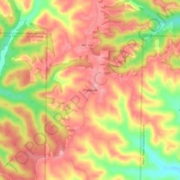
Nom : Carte topographique Chadwick, altitude, relief.
Lieu : Chadwick, Christian County, Missouri, 65629, United States (36.91006 -93.07684 36.95006 -93.03684)
Altitude moyenne : 385 m
Altitude minimum : 314 m
Altitude maximum : 424 m
Faire un don
Équipez-vous pour votre prochaine aventure :
En tant que Partenaire Amazon, ce site perçoit une commission sur les achats éligibles sans surcoût pour vous.
Autres cartes topographiques
Cliquez sur une carte pour visualiser sa topographie, son altitude et son relief.
Nixa
United States > Missouri > Christian County
Nixa Public Schools operates four elementary schools for students in kindergarten through fourth grade: Helen-Matthews Elementary, Espy Elementary, Century Elementary, and the newest, High Pointe Elementary (named because it sits on the highest elevation in Christian County), opened in August 2007. Two…
Altitude moyenne : 380 m
Highlandville
United States > Missouri > Christian County
A post office called Highlandville has been in operation since 1872. The city was named on account of its lofty elevation.
Altitude moyenne : 385 m
Faire un don
Équipez-vous pour votre prochaine aventure :
En tant que Partenaire Amazon, ce site perçoit une commission sur les achats éligibles sans surcoût pour vous.
Clever
United States > Missouri > Christian County
Clever is located on the Springfield Plateau of the Missouri Ozarks, 14.5 miles (23.3 km) southwest of Springfield at an elevation of 1,398 feet (426 m). The town lies in the western panhandle of Christian County, just south of Missouri Highway 14 between Nixa and Billings. The town of Republic and the…
Altitude moyenne : 397 m
Faire un don
Équipez-vous pour votre prochaine aventure :
En tant que Partenaire Amazon, ce site perçoit une commission sur les achats éligibles sans surcoût pour vous.