
Carte topographique Stevens Pass
Carte interactive
Cliquez sur la carte pour afficher l’altitude.
À propos de cette carte
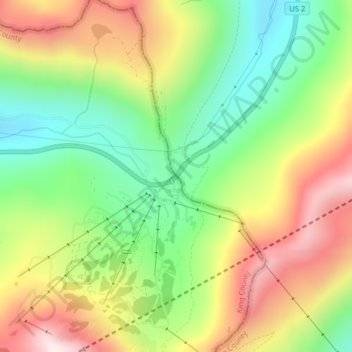
Nom : Carte topographique Stevens Pass, altitude, relief.
Lieu : Stevens Pass, King County, Washington, United States (47.74559 -121.08922 47.74569 -121.08912)
Altitude moyenne : 1.387 m
Altitude minimum : 1.093 m
Altitude maximum : 1.753 m
Stevens Pass (elevation 4,061 ft (1,238 m)) is a mountain pass through the Cascade Mountains located at the border of King County and Chelan County in Washington, United States. U.S. Route 2 travels over the pass, reaching a maximum elevation of 4,061 feet (1,238 m). The Pacific Crest Trail crosses the highway at Stevens Pass. The BNSF Railway's Cascade Tunnel lies 1,180 feet (400 m) below the pass summit.
Autres cartes topographiques
Cliquez sur une carte pour visualiser sa topographie, son altitude et son relief.
Bothell
United States > Washington > King County
Bothell, King County, Washington, United States
Altitude moyenne : 68 m
Bellevue
United States > Washington > King County
Bellevue, King County, Washington, United States
Altitude moyenne : 66 m
Seattle
United States > Washington > King County
Seattle, King County, Washington, United States
Altitude moyenne : 40 m
Factoria
United States > Washington > King County > Bellevue
Factoria, Bellevue, King County, Washington, 98006, United States
Altitude moyenne : 75 m
Azure Lake
United States > Washington > King County
Azure Lake, King County, Washington, United States
Altitude moyenne : 1.529 m
Sammamish
United States > Washington > King County
Sammamish, King County, Washington, United States
Altitude moyenne : 97 m
Burien
United States > Washington > King County
Burien, King County, Washington, United States
Altitude moyenne : 65 m
Maplewood
United States > Washington > King County > Renton
Maplewood, Renton, King County, Washington, 98058, United States
Altitude moyenne : 102 m
Lake City Memorial Triangle
United States > Washington > King County > Seattle
Lake City Memorial Triangle, 12354, Lake City, Seattle, King County, Washington, 98125, United States
Altitude moyenne : 61 m
White Center
United States > Washington > King County
White Center, King County, Washington, 98146, United States
Altitude moyenne : 58 m
Grotto
United States > Washington > King County
Grotto, King County, Washington, 98224, United States
Altitude moyenne : 528 m
Moira Lake
United States > Washington > King County
Moira Lake, King County, Washington, United States
Altitude moyenne : 1.303 m
Jones Lake
United States > Washington > King County > Black Diamond
Jones Lake, Black Diamond, King County, Washington, United States
Altitude moyenne : 210 m
Woodinville
United States > Washington > King County
Woodinville, King County, Washington, United States
Altitude moyenne : 73 m
Annette Lake
United States > Washington > King County
Annette Lake, King County, Washington, United States
Altitude moyenne : 1.318 m
Renton
United States > Washington > King County
Renton, King County, Washington, United States
Altitude moyenne : 83 m
Shoreline
United States > Washington > King County
Shoreline, King County, Washington, 98155, United States
Altitude moyenne : 99 m
Auburn
United States > Washington > King County
Auburn, King County, Washington, United States
Altitude moyenne : 88 m
Five Mile Lake
United States > Washington > King County > Lakeland South
Five Mile Lake, Lakeland South, King County, Washington, United States
Altitude moyenne : 115 m
Woodinville
United States > Washington > King County > Woodinville > Woodinville
Woodinville, King County, Washington, 98072, United States
Altitude moyenne : 80 m
SeaTac
United States > Washington > King County
SeaTac, King County, Washington, United States
Altitude moyenne : 60 m
Mercer Island
United States > Washington > King County > Mercer Island
Mercer Island, King County, Washington, 98040, United States
Altitude moyenne : 39 m
Green Lake
United States > Washington > King County > Seattle
Green Lake, Seattle, King County, Washington, 98103, United States
Altitude moyenne : 75 m
Kirkland
United States > Washington > King County
Kirkland, King County, Washington, United States
Altitude moyenne : 58 m
Kent
United States > Washington > King County
Kent, King County, Washington, United States
Altitude moyenne : 87 m
Maple Valley
United States > Washington > King County
Maple Valley, King County, Washington, 98038, United States
Altitude moyenne : 160 m
Kenmore
United States > Washington > King County
Kenmore, King County, Washington, 98028, United States
Altitude moyenne : 59 m
Snoqualmie
United States > Washington > King County
Snoqualmie, King County, Washington, 98065, United States
Altitude moyenne : 213 m
Issaquah
United States > Washington > King County
Issaquah, King County, Washington, United States
Altitude moyenne : 164 m
Redmond
United States > Washington > King County
Redmond, King County, Washington, United States
Altitude moyenne : 72 m
Federal Way
United States > Washington > King County
Federal Way, King County, Washington, United States
Altitude moyenne : 81 m