
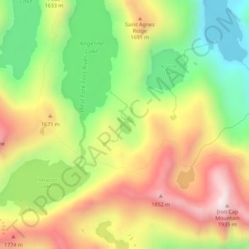
Carte topographique Azure Lake
Carte interactive
Cliquez sur la carte pour afficher l’altitude.
À propos de cette carte
Nom : Carte topographique Azure Lake, altitude, relief.
Lieu : Azure Lake, King County, Washington, United States (47.56177 -121.30248 47.56376 -121.29971)
Altitude moyenne : 1.529 m
Altitude minimum : 1.188 m
Altitude maximum : 1.904 m
Autres cartes topographiques
Cliquez sur une carte pour visualiser sa topographie, son altitude et son relief.
Bothell
United States > Washington > King County
Bothell, King County, Washington, United States
Altitude moyenne : 68 m
Bellevue
United States > Washington > King County
Bellevue, King County, Washington, United States
Altitude moyenne : 66 m
Seattle
United States > Washington > King County
Seattle, King County, Washington, United States
Altitude moyenne : 40 m
Factoria
United States > Washington > King County > Bellevue
Factoria, Bellevue, King County, Washington, 98006, United States
Altitude moyenne : 75 m
Sammamish
United States > Washington > King County
Sammamish, King County, Washington, United States
Altitude moyenne : 97 m
Burien
United States > Washington > King County
Burien, King County, Washington, United States
Altitude moyenne : 65 m
Maplewood
United States > Washington > King County > Renton
Maplewood, Renton, King County, Washington, 98058, United States
Altitude moyenne : 102 m
Lake City Memorial Triangle
United States > Washington > King County > Seattle
Lake City Memorial Triangle, 12354, Lake City, Seattle, King County, Washington, 98125, United States
Altitude moyenne : 61 m
White Center
United States > Washington > King County
White Center, King County, Washington, 98146, United States
Altitude moyenne : 58 m
Stevens Pass
United States > Washington > King County
Stevens Pass, King County, Washington, United States
Altitude moyenne : 1.387 m
Grotto
United States > Washington > King County
Grotto, King County, Washington, 98224, United States
Altitude moyenne : 528 m
Moira Lake
United States > Washington > King County
Moira Lake, King County, Washington, United States
Altitude moyenne : 1.303 m
Jones Lake
United States > Washington > King County > Black Diamond
Jones Lake, Black Diamond, King County, Washington, United States
Altitude moyenne : 210 m
Woodinville
United States > Washington > King County
Woodinville, King County, Washington, United States
Altitude moyenne : 73 m
Annette Lake
United States > Washington > King County
Annette Lake, King County, Washington, United States
Altitude moyenne : 1.318 m
Renton
United States > Washington > King County
Renton, King County, Washington, United States
Altitude moyenne : 83 m
Shoreline
United States > Washington > King County
Shoreline, King County, Washington, 98155, United States
Altitude moyenne : 99 m
Auburn
United States > Washington > King County
Auburn, King County, Washington, United States
Altitude moyenne : 88 m
Five Mile Lake
United States > Washington > King County > Lakeland South
Five Mile Lake, Lakeland South, King County, Washington, United States
Altitude moyenne : 115 m
Woodinville
United States > Washington > King County > Woodinville > Woodinville
Woodinville, King County, Washington, 98072, United States
Altitude moyenne : 80 m
SeaTac
United States > Washington > King County
SeaTac, King County, Washington, United States
Altitude moyenne : 60 m
Mercer Island
United States > Washington > King County > Mercer Island
Mercer Island, King County, Washington, 98040, United States
Altitude moyenne : 39 m
Green Lake
United States > Washington > King County > Seattle
Green Lake, Seattle, King County, Washington, 98103, United States
Altitude moyenne : 75 m
Kirkland
United States > Washington > King County
Kirkland, King County, Washington, United States
Altitude moyenne : 58 m
Kent
United States > Washington > King County
Kent, King County, Washington, United States
Altitude moyenne : 87 m
Maple Valley
United States > Washington > King County
Maple Valley, King County, Washington, 98038, United States
Altitude moyenne : 160 m
Kenmore
United States > Washington > King County
Kenmore, King County, Washington, 98028, United States
Altitude moyenne : 59 m
Snoqualmie
United States > Washington > King County
Snoqualmie, King County, Washington, 98065, United States
Altitude moyenne : 213 m
Issaquah
United States > Washington > King County
Issaquah, King County, Washington, United States
Altitude moyenne : 164 m
Redmond
United States > Washington > King County
Redmond, King County, Washington, United States
Altitude moyenne : 72 m
Federal Way
United States > Washington > King County
Federal Way, King County, Washington, United States
Altitude moyenne : 81 m