
Faire un don
Équipez-vous pour votre prochaine aventure :
En tant que Partenaire Amazon, ce site perçoit une commission sur les achats éligibles sans surcoût pour vous.
Carte topographique Solana
Cliquez sur la carte pour afficher l’altitude.
Faire un don
Équipez-vous pour votre prochaine aventure :
En tant que Partenaire Amazon, ce site perçoit une commission sur les achats éligibles sans surcoût pour vous.
À propos de cette carte
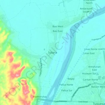
Nom : Carte topographique Solana, altitude, relief.
Lieu : Solana, Cagayan, Cagayan Valley, 3503, Philippines (17.61094 121.65092 17.69094 121.73092)
Altitude moyenne : 33 m
Altitude minimum : 9 m
Altitude maximum : 154 m
Faire un don
Équipez-vous pour votre prochaine aventure :
En tant que Partenaire Amazon, ce site perçoit une commission sur les achats éligibles sans surcoût pour vous.
Autres cartes topographiques
Cliquez sur une carte pour visualiser sa topographie, son altitude et son relief.
Fuga Island
Fuga has an area of 70 square kilometres (27 sq mi) and a population of 2,015 people. The principal settlement is Naguilian (Musa) village on the southern coast. The highest peak is Mount Nanguringan in the northeast, with an elevation of 191 metres (627 ft).
Altitude moyenne : 9 m
Faire un don
Équipez-vous pour votre prochaine aventure :
En tant que Partenaire Amazon, ce site perçoit une commission sur les achats éligibles sans surcoût pour vous.
Dalupiri Island
Philippines > Cagayan > Calayan
Dalupiri Island lies about 45 km (28 mi) north of Luzon and about 15 km (9.3 mi) north of Fuga Island. The island has an elongated elliptical shape orientated along a north–south axis, the island has a length of about 18 km (11 mi), with a width of about 7 km (4.3 mi) at its widest point. The topography of…
Altitude moyenne : 25 m