
Faire un don
Équipez-vous pour votre prochaine aventure :
En tant que Partenaire Amazon, ce site perçoit une commission sur les achats éligibles sans surcoût pour vous.
Carte topographique Dalupiri Island
Cliquez sur la carte pour afficher l’altitude.
Faire un don
Équipez-vous pour votre prochaine aventure :
En tant que Partenaire Amazon, ce site perçoit une commission sur les achats éligibles sans surcoût pour vous.
Dalupiri Island
Dalupiri Island lies about 45 km (28 mi) north of Luzon and about 15 km (9.3 mi) north of Fuga Island. The island has an elongated elliptical shape orientated along a north–south axis, the island has a length of about 18 km (11 mi), with a width of about 7 km (4.3 mi) at its widest point. The topography of the island is characterized by a flat hilly landscape, in the center of the island, the terrain rises to 297 metres (974 ft) above sea level. The island has an area of 166 square kilometres (64 sq mi). The longest river of the island is the Manolong River, about 2.5 km long.
Faire un don
Équipez-vous pour votre prochaine aventure :
En tant que Partenaire Amazon, ce site perçoit une commission sur les achats éligibles sans surcoût pour vous.
À propos de cette carte
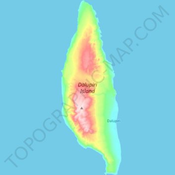
Nom : Carte topographique Dalupiri Island, altitude, relief.
Altitude moyenne : 25 m
Altitude minimum : 0 m
Altitude maximum : 282 m
Faire un don
Équipez-vous pour votre prochaine aventure :
En tant que Partenaire Amazon, ce site perçoit une commission sur les achats éligibles sans surcoût pour vous.
Autres cartes topographiques
Cliquez sur une carte pour visualiser sa topographie, son altitude et son relief.