
Carte topographique Rogers
Carte interactive
Cliquez sur la carte pour afficher l’altitude.
À propos de cette carte
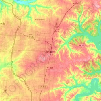
Nom : Carte topographique Rogers, altitude, relief.
Lieu : Rogers, Benton County, Arkansas, United States (36.26279 -94.25074 36.40610 -94.08062)
Altitude moyenne : 393 m
Altitude minimum : 326 m
Altitude maximum : 439 m
Autres cartes topographiques
Cliquez sur une carte pour visualiser sa topographie, son altitude et son relief.
Bentonville
United States > Arkansas > Benton County
Bentonville, Benton County, Arkansas, United States
Altitude moyenne : 387 m
Monte Ne Shores
United States > Arkansas > Benton County
Monte Ne Shores, Benton County, Arkansas, United States
Altitude moyenne : 380 m
Lowell
United States > Arkansas > Benton County
Lowell, Benton County, Arkansas, United States
Altitude moyenne : 404 m
Maysville
United States > Arkansas > Benton County
Maysville, Benton County, Arkansas, 72747, United States
Altitude moyenne : 323 m
Gravette
United States > Arkansas > Benton County
Gravette, Benton County, Arkansas, United States
Altitude moyenne : 356 m
Prairie Creek
United States > Arkansas > Benton County > Rogers
Prairie Creek, Rogers, Benton County, Arkansas, United States
Altitude moyenne : 389 m
Garfield
United States > Arkansas > Benton County
Garfield, Benton County, Arkansas, 72732, United States
Altitude moyenne : 453 m
Hiwasse
United States > Arkansas > Benton County > Gravette
Hiwasse, Gravette, Benton County, Arkansas, 72739, United States
Altitude moyenne : 394 m
Siloam Springs
United States > Arkansas > Benton County
Siloam Springs, Benton County, Arkansas, 72761, United States
Altitude moyenne : 339 m
Blowing Springs Bike & Fitness Park
United States > Arkansas > Benton County > Bella Vista
Blowing Springs Bike & Fitness Park, Bella Vista, Benton County, Arkansas, 72715, United States
Altitude moyenne : 351 m
Centerton
United States > Arkansas > Benton County
Centerton, Benton County, Arkansas, 72719, United States
Altitude moyenne : 393 m
Norwood
United States > Arkansas > Benton County
Norwood, Benton County, Arkansas, United States
Altitude moyenne : 347 m
Bentonville
United States > Arkansas > Benton County > Bentonville > Bentonville
Bentonville, Benton County, Arkansas, 72712, United States
Altitude moyenne : 383 m
Bella Vista
United States > Arkansas > Benton County
Bella Vista, Benton County, Arkansas, 72715, United States
Altitude moyenne : 372 m
Rago
United States > Arkansas > Benton County > Bella Vista > Rago
Rago, Bella Vista, Benton County, Arkansas, 72715, United States
Altitude moyenne : 378 m