
Faire un don
Équipez-vous pour votre prochaine aventure :
En tant que Partenaire Amazon, ce site perçoit une commission sur les achats éligibles sans surcoût pour vous.
Carte topographique Bentonville
Cliquez sur la carte pour afficher l’altitude.
Faire un don
Équipez-vous pour votre prochaine aventure :
En tant que Partenaire Amazon, ce site perçoit une commission sur les achats éligibles sans surcoût pour vous.
Bentonville
Bentonville lies in the humid subtropical climate zone (Köppen Cfa) with influence from the humid continental climate type. Bentonville experiences all four seasons and does receive cold air masses from the north, however some of the Arctic masses are blocked by the higher elevations of the Ozarks. July is the hottest month of the year, with an average high of 89 °F (32 °C) and an average low of 66 °F (19 °C). Temperatures above 90 °F (32.2 °C) are common, with a high of 100 °F (37.8 °C) occurring about once per year on average. January is the coldest month with an average high of 46 °F (8 °C) and an average low of 24 °F (−4 °C). The city's highest temperature was 114 °F (45.6 °C), recorded in 1954. The lowest temperature recorded was −16 °F (−26.7 °C), in 1996.
Faire un don
Équipez-vous pour votre prochaine aventure :
En tant que Partenaire Amazon, ce site perçoit une commission sur les achats éligibles sans surcoût pour vous.
À propos de cette carte
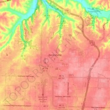
Nom : Carte topographique Bentonville, altitude, relief.
Lieu : Bentonville, Benton County, Arkansas, 72712, United States (36.33285 -94.24882 36.41285 -94.16882)
Altitude moyenne : 383 m
Altitude minimum : 319 m
Altitude maximum : 407 m
Faire un don
Équipez-vous pour votre prochaine aventure :
En tant que Partenaire Amazon, ce site perçoit une commission sur les achats éligibles sans surcoût pour vous.