
Carte topographique Trient
Carte interactive
Cliquez sur la carte pour afficher l’altitude.
À propos de cette carte
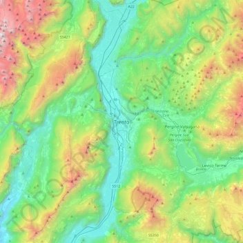
Nom : Carte topographique Trient, altitude, relief.
Altitude moyenne : 970 m
Altitude minimum : 93 m
Altitude maximum : 3.117 m
Die Stadt liegt, umgeben von Bergen, im Etschtal direkt an der Etsch, 55 km südlich von Bozen und 100 km nördlich von Verona. Ihr Zentrum befindet sich auf einer Höhe von 194 m ü. NHN. Das Gemeindegebiet erstreckt sich über eine Fläche von 158 km².
Autres cartes topographiques
Cliquez sur une carte pour visualiser sa topographie, son altitude et son relief.
Vason
Italien > Trentino-Südtirol > Autonome Provinz Trient > Trient
Vason, Trient, Territorio Val d'Adige, Autonome Provinz Trient, Trentino-Südtirol, Italien
Altitude moyenne : 1.344 m
Vaneze
Italien > Trentino-Südtirol > Autonome Provinz Trient > Trient
Vaneze, Trient, Territorio Val d'Adige, Autonome Provinz Trient, Trentino-Südtirol, Italien
Altitude moyenne : 1.014 m
Candriai
Italien > Trentino-Südtirol > Autonome Provinz Trient > Trient > Sardagna
Candriai, Sardagna, Trient, Territorio Val d'Adige, Autonome Provinz Trient, Trentino-Südtirol, 38122, Italien
Altitude moyenne : 744 m
Sopramonte
Italien > Trentino-Südtirol > Autonome Provinz Trient > Trient
Sopramonte, Trient, Territorio Val d'Adige, Autonome Provinz Trient, Trentino-Südtirol, Italien
Altitude moyenne : 718 m