
Carte topographique Sopramonte
Carte interactive
Cliquez sur la carte pour afficher l’altitude.
À propos de cette carte
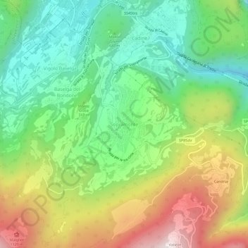
Nom : Carte topographique Sopramonte, altitude, relief.
Altitude moyenne : 718 m
Altitude minimum : 341 m
Altitude maximum : 1.320 m
Autres cartes topographiques
Cliquez sur une carte pour visualiser sa topographie, son altitude et son relief.
Vason
Italien > Trentino-Südtirol > Autonome Provinz Trient > Trient
Vason, Trient, Territorio Val d'Adige, Autonome Provinz Trient, Trentino-Südtirol, Italien
Altitude moyenne : 1.344 m
Vaneze
Italien > Trentino-Südtirol > Autonome Provinz Trient > Trient
Vaneze, Trient, Territorio Val d'Adige, Autonome Provinz Trient, Trentino-Südtirol, Italien
Altitude moyenne : 1.014 m
Candriai
Italien > Trentino-Südtirol > Autonome Provinz Trient > Trient > Sardagna
Candriai, Sardagna, Trient, Territorio Val d'Adige, Autonome Provinz Trient, Trentino-Südtirol, 38122, Italien
Altitude moyenne : 744 m
Trient
Italien > Trentino-Südtirol > Autonome Provinz Trient > Trient
Trient, Territorio Val d'Adige, Autonome Provinz Trient, Trentino-Südtirol, 38122, Italien
Altitude moyenne : 970 m