
Carte topographique Lägh dal Lunghin
Carte interactive
Cliquez sur la carte pour afficher l’altitude.
À propos de cette carte
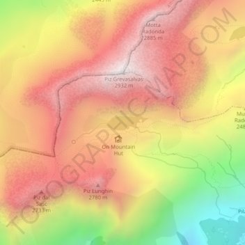
Nom : Carte topographique Lägh dal Lunghin, altitude, relief.
Lieu : Lägh dal Lunghin, Bregaglia, Maloja, Grisons, Switzerland (46.41656 9.67187 46.41814 9.67833)
Altitude moyenne : 2.456 m
Altitude minimum : 1.771 m
Altitude maximum : 2.915 m
Lägh dal Lunghin (German: Lunghinsee) is a lake at an elevation of 2484 m, below the peak of Piz Lunghin, in the Graubünden, Switzerland. It is considered the source of the Inn River.
Autres cartes topographiques
Cliquez sur une carte pour visualiser sa topographie, son altitude et son relief.
Crastas
Switzerland > Grisons > Maloja > Sils im Engadin/Segl
Crastas, Sils im Engadin/Segl, Maloja, Grisons, 7514, Switzerland
Altitude moyenne : 2.060 m
Samedan
Switzerland > Grisons > Maloja
Samedan, Maloja, Grisons, 7503, Switzerland
Altitude moyenne : 2.501 m
Albulapass
Switzerland > Grisons > Maloja > La Punt Chamues-ch
Albulapass, La Punt Chamues-ch, Maloja, Grisons, 7522, Switzerland
Altitude moyenne : 2.560 m
Orden
Switzerland > Grisons > Maloja > Maloja
Orden, Maloja, Bregaglia, Maloja, Grisons, 7516, Switzerland
Altitude moyenne : 1.988 m
Silvaplana
Switzerland > Grisons > Maloja > Silvaplana > Silvaplana
Silvaplana, Maloja, Grisons, 7513, Switzerland
Altitude moyenne : 2.027 m
Sankt Moritz
Switzerland > Grisons > Maloja > Sankt Moritz > Sankt Moritz
Sankt Moritz, Maloja, Grisons, 7500, Switzerland
Altitude moyenne : 2.185 m
Pontresina
Switzerland > Grisons > Maloja > Pontresina > Pontresina
Pontresina, Maloja, Grisons, 7504, Switzerland
Altitude moyenne : 2.110 m
Sankt Moritz
Switzerland > Grisons > Maloja
Sankt Moritz, Maloja, Grisons, 7500, Switzerland
Altitude moyenne : 2.173 m
Pontresina
Switzerland > Grisons > Maloja
Pontresina, Maloja, Grisons, 7504, Switzerland
Altitude moyenne : 2.580 m
La Punt Chamues-ch
Switzerland > Grisons > Maloja
La Punt Chamues-ch, Maloja, Grisons, 7522, Switzerland
Altitude moyenne : 2.287 m