
Carte topographique Siniloan
Cliquez sur la carte pour afficher l’altitude.
Siniloan
Buruwisan falls is located in Siniloan Laguna which is around eighty kilometers east of Manila. To get there we had to cross the long winding roads of Teresa and Bugarin to Mabitac. By public transport Take UV express vans bound to Tanay market in Starmall-Shaw terminal (P70). Then in Tanay market, ride a jeepney going to Siniloan (P47). In Siniloan, take a tricycle to Brgy Macatad (Mt Romelo's jumpoff) (P20). By private transport From Manila, Take the east-bound lane of Ortigas Avenue going to Antipolo. Then take the Manila-east route going to Famy, Laguna. From here jump off is less than 10 minutes away via Siniloan-Famy-Real-Infanta Road. Major Jump-off: Barangay Macatad, �Elevation: 300 MASL�Days required / hours to summit: 1 day, 2–3 hours�Specs: Minor Climb, Difficulty 2/9, Trail Class 1�Features: Waterfalls, rain forest
À propos de cette carte
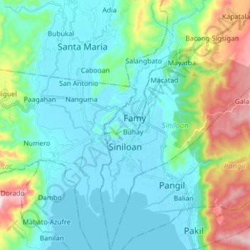
Nom : Carte topographique Siniloan, altitude, relief.
Lieu : Siniloan, Laguna, Calabarzon, 4019, Philippines (14.37150 121.43183 14.49245 121.51328)
Altitude moyenne : 120 m
Altitude minimum : -5 m
Altitude maximum : 545 m
Autres cartes topographiques
Cliquez sur une carte pour visualiser sa topographie, son altitude et son relief.
Mount Makiling
Philippines > Laguna > Los Baños
Mount Makiling (also spelled Maquiling) is an inactive stratovolcano located in the provinces of Laguna and Batangas on the island of Luzon in the Philippines. The mountain rises to an elevation of 1,090 meters (3,580 ft) above mean sea level and is the highest feature of the Laguna Volcanic Field. The volcano…
Altitude moyenne : 753 m