
Carte topographique Mount Makiling
Cliquez sur la carte pour afficher l’altitude.
Mount Makiling
Mount Makiling (also spelled Maquiling) is an inactive stratovolcano located in the provinces of Laguna and Batangas on the island of Luzon in the Philippines. The mountain rises to an elevation of 1,090 meters (3,580 ft) above mean sea level and is the highest feature of the Laguna Volcanic Field. The volcano has no recorded historic eruption but volcanism is still evident through geothermal features like mud spring and hot springs. South of the mountain is the Makiling–Banahaw Geothermal Plant. The Philippine Institute of Volcanology and Seismology (PHIVOLCS) classifies the volcano as "Inactive".
À propos de cette carte
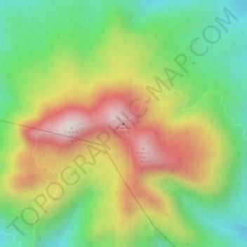
Nom : Carte topographique Mount Makiling, altitude, relief.
Lieu : Mount Makiling, Los Baños, Laguna, Calabarzon, Philippines (14.13517 121.19440 14.13527 121.19450)
Altitude moyenne : 753 m
Altitude minimum : 467 m
Altitude maximum : 1.076 m
Autres cartes topographiques
Cliquez sur une carte pour visualiser sa topographie, son altitude et son relief.