
Carte topographique Kidapawan
Cliquez sur la carte pour afficher l’altitude.
Kidapawan
Within the Mt. Apo Natural Park is the Mandarangan Geological Site, which is being promoted as a major educational tourism site. Lake Venado, hidden among the mountain ranges, stands at an elevation of 7,200 feet (2,200 m) above sea level.
À propos de cette carte
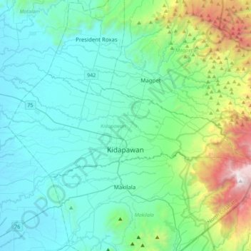
Nom : Carte topographique Kidapawan, altitude, relief.
Lieu : Kidapawan, North Cotabato, Soccsksargen, 9400, Philippines (6.97163 124.93130 7.11167 125.27100)
Altitude moyenne : 495 m
Altitude minimum : 33 m
Altitude maximum : 2.600 m
Autres cartes topographiques
Cliquez sur une carte pour visualiser sa topographie, son altitude et son relief.