
Carte topographique Kirkcaldy
Carte interactive
Cliquez sur la carte pour afficher l’altitude.
À propos de cette carte
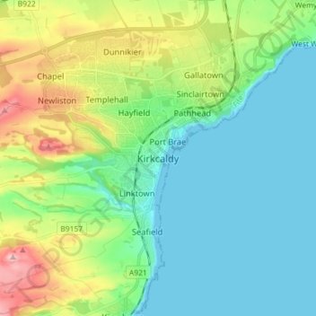
Nom : Carte topographique Kirkcaldy, altitude, relief.
Lieu : Kirkcaldy, Fife, Scotland, KY1 1JA, United Kingdom (56.07102 -3.19823 56.15102 -3.11823)
Altitude moyenne : 50 m
Altitude minimum : -1 m
Altitude maximum : 185 m
Towards the end of the 16th century, a detailed assessment on the size of the townscape was carried out. The first estimate of the parish population in 1639 was between 3,000 and 3,200 and around 3,400 by 1691. At the beginning of the 18th century, the population declined. A census by Webster's Topographical Dictionary of Scotland in 1755, recorded an estimate of 2,296 in the parish. By the time of the first nationwide UK census in 1801, the population had risen to 3,248. The population of the burgh was recorded as 4,785 in the 1841 Census, and had risen to 34,079 by 1901. By the time of the 1951 Census, the figure stood at 49,050.
Autres cartes topographiques
Cliquez sur une carte pour visualiser sa topographie, son altitude et son relief.
St Andrews
United Kingdom > Scotland > Fife
St Andrews, Fife, Scotland, KY16 9PA, United Kingdom
Altitude moyenne : 38 m
Glenrothes
United Kingdom > Scotland > Fife
Glenrothes, Fife, Scotland, KY7 5LW, United Kingdom
Altitude moyenne : 106 m
Freuchie
United Kingdom > Scotland > Fife
Freuchie, Fife, Scotland, KY15 7EJ, United Kingdom
Altitude moyenne : 78 m
Elie and Earlsferry
United Kingdom > Scotland > Fife > Elie and Earlsferry
Elie and Earlsferry, Fife, Scotland, KY9 1BD, United Kingdom
Altitude moyenne : 10 m
Falkland
United Kingdom > Scotland > Fife
Falkland, Fife, Scotland, KY15 7BU, United Kingdom
Altitude moyenne : 133 m
Kincardine
United Kingdom > Scotland > Fife
Kincardine, Fife, Scotland, FK10 4NE, United Kingdom
Altitude moyenne : 22 m