
Carte topographique Kincardine
Carte interactive
Cliquez sur la carte pour afficher l’altitude.
À propos de cette carte
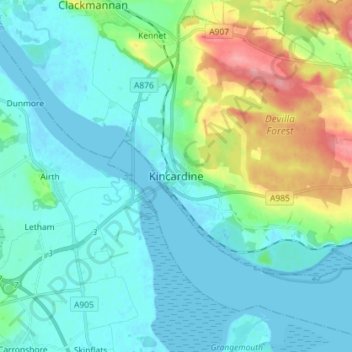
Nom : Carte topographique Kincardine, altitude, relief.
Lieu : Kincardine, Fife, Scotland, FK10 4NE, United Kingdom (56.02840 -3.75846 56.10840 -3.67846)
Altitude moyenne : 22 m
Altitude minimum : -3 m
Altitude maximum : 103 m
Autres cartes topographiques
Cliquez sur une carte pour visualiser sa topographie, son altitude et son relief.
St Andrews
United Kingdom > Scotland > Fife
St Andrews, Fife, Scotland, KY16 9PA, United Kingdom
Altitude moyenne : 38 m
Kirkcaldy
United Kingdom > Scotland > Fife
Kirkcaldy, Fife, Scotland, KY1 1JA, United Kingdom
Altitude moyenne : 50 m
Glenrothes
United Kingdom > Scotland > Fife
Glenrothes, Fife, Scotland, KY7 5LW, United Kingdom
Altitude moyenne : 106 m
Freuchie
United Kingdom > Scotland > Fife
Freuchie, Fife, Scotland, KY15 7EJ, United Kingdom
Altitude moyenne : 78 m
Elie and Earlsferry
United Kingdom > Scotland > Fife > Elie and Earlsferry
Elie and Earlsferry, Fife, Scotland, KY9 1BD, United Kingdom
Altitude moyenne : 10 m
Falkland
United Kingdom > Scotland > Fife
Falkland, Fife, Scotland, KY15 7BU, United Kingdom
Altitude moyenne : 133 m