
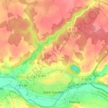
Carte topographique Saint-Gaultier
Carte interactive
Cliquez sur la carte pour afficher l’altitude.
À propos de cette carte
Nom : Carte topographique Saint-Gaultier, altitude, relief.
Altitude moyenne : 134 m
Altitude minimum : 80 m
Altitude maximum : 170 m
Autres cartes topographiques
Cliquez sur une carte pour visualiser sa topographie, son altitude et son relief.
Lys-Saint-Georges
France > Centre-Val de Loire > Indre
Lys-Saint-Georges, La Châtre, Indre, Centre-Val de Loire, France métropolitaine, 36230, France
Altitude moyenne : 188 m
Châteauroux
France > Centre-Val de Loire > Indre > Châteauroux
Châteauroux, Indre, Centre-Val de Loire, France métropolitaine, 36000, France
Altitude moyenne : 153 m
Hurtebise
France > Centre-Val de Loire > Indre > Villegongis
Hurtebise, Villegongis, Châteauroux, Indre, Centre-Val de Loire, France métropolitaine, 36110, France
Altitude moyenne : 156 m
Murs
France > Centre-Val de Loire > Indre
Murs, Châteauroux, Indre, Centre-Val de Loire, France métropolitaine, 36700, France
Altitude moyenne : 131 m