
Carte topographique Warwick
Carte interactive
Cliquez sur la carte pour afficher l’altitude.
À propos de cette carte
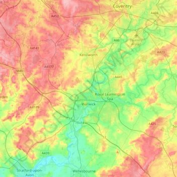
Nom : Carte topographique Warwick, altitude, relief.
Lieu : Warwick, Warwickshire, West Midlands, England, United Kingdom (52.21370 -1.78018 52.38928 -1.40608)
Altitude moyenne : 87 m
Altitude minimum : 35 m
Altitude maximum : 145 m
Warwick experiences the usual English maritime climate, marked by a narrow temperature range, mild winters and cool summers. The nearest official Met Office weather station is at Wellesbourne, about 6 miles (10 km) south of the town centre and at a similar elevation.
Autres cartes topographiques
Cliquez sur une carte pour visualiser sa topographie, son altitude et son relief.
Warwick Castle
United Kingdom > England > Warwickshire > Warwick
Warwick Castle, Northern Tower, Cliff Hill, Warwick, Warwickshire, England, CV34 4QX, United Kingdom
Altitude moyenne : 56 m
Sherbourne
United Kingdom > England > Warwickshire > Warwick
Sherbourne, Warwick, Warwickshire, England, United Kingdom
Altitude moyenne : 56 m
Leek Wootton
United Kingdom > England > Warwickshire > Warwick
Leek Wootton, Warwick, Warwickshire, England, CV35 7RS, United Kingdom
Altitude moyenne : 76 m