
Carte topographique Chobham
Cliquez sur la carte pour afficher l’altitude.
Chobham
The rolling basin below reaches lowest elevations of between 30 metres (98 ft) in the centre of the west and 20 metres (66 ft) where the rivers join in the centre of the east. The rivers at the western point are less than 100 metres (330 ft) apart; to the east end of the parish where the parish adjoins the landscape of the McLaren Technology Centre the rivers are finally merged along that boundary.
À propos de cette carte
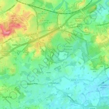
Nom : Carte topographique Chobham, altitude, relief.
Lieu : Chobham, Surrey Heath, Surrey, England, United Kingdom (51.33363 -0.64098 51.39246 -0.54851)
Altitude moyenne : 43 m
Altitude minimum : 19 m
Altitude maximum : 99 m
Autres cartes topographiques
Cliquez sur une carte pour visualiser sa topographie, son altitude et son relief.
Camberley
United Kingdom > England > Surrey > Surrey Heath
The Staff College, to the north of Camberley town centre, is part of the Joint Services Command and Staff College, which provides training and education for established officers in the British Armed Forces and civil servants in the Ministry of Defence. The institution has its origins in the Royal Military…
Altitude moyenne : 88 m
Bagshot Park Mansion
United Kingdom > England > Surrey > Surrey Heath > Bagshot
Altitude moyenne : 76 m
Frimley Lodge Park
United Kingdom > England > Surrey > Surrey Heath > Frimley Green
Altitude moyenne : 80 m
Kalima Caravan Site
United Kingdom > England > Surrey > Surrey Heath > Chobham
Altitude moyenne : 28 m
Camberley
United Kingdom > England > Surrey > Surrey Heath
The Staff College, to the north of Camberley town centre, is part of the Joint Services Command and Staff College, which provides training and education for established officers in the British Armed Forces and civil servants in the Ministry of Defence. The institution has its origins in the Royal Military…
Altitude moyenne : 88 m