
Carte topographique Oberkreith
Carte interactive
Cliquez sur la carte pour afficher l’altitude.
À propos de cette carte
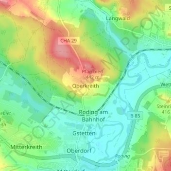
Nom : Carte topographique Oberkreith, altitude, relief.
Lieu : Oberkreith, Roding, Landkreis Cham, Bayern, 93426, Deutschland (49.20062 12.49219 49.24062 12.53219)
Altitude moyenne : 386 m
Altitude minimum : 353 m
Altitude maximum : 448 m
Autres cartes topographiques
Cliquez sur une carte pour visualiser sa topographie, son altitude et son relief.
Heidersberg
Deutschland > Bayern > Landkreis Cham > Roding
Heidersberg, Roding, Landkreis Cham, Bayern, 93483, Deutschland
Altitude moyenne : 415 m
Wetterfeld
Deutschland > Bayern > Landkreis Cham > Roding
Wetterfeld, Roding, Landkreis Cham, Bayern, 93483, Deutschland
Altitude moyenne : 388 m
Trasching
Deutschland > Bayern > Landkreis Cham > Roding
Trasching, Roding, Landkreis Cham, Bayern, Deutschland
Altitude moyenne : 463 m
Strahlfeld
Deutschland > Bayern > Landkreis Cham > Roding
Strahlfeld, Roding, Landkreis Cham, Bayern, 93426, Deutschland
Altitude moyenne : 413 m