
Carte topographique Trasching
Cliquez sur la carte pour afficher l’altitude.
À propos de cette carte
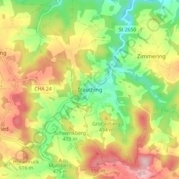
Nom : Carte topographique Trasching, altitude, relief.
Lieu : Trasching, Roding, Landkreis Cham, Bayern, Deutschland (49.13559 12.44075 49.17559 12.48075)
Altitude moyenne : 463 m
Altitude minimum : 364 m
Altitude maximum : 574 m
Autres cartes topographiques
Cliquez sur une carte pour visualiser sa topographie, son altitude et son relief.
Burgruine Schwärzenburg
Deutschland > Bayern > Landkreis Cham > Roding > Strahlfeld
Die Höhenburg wurde vermutlich im 13. Jahrhundert auf dem Grund des Bamberger Bischofs von den Herren von Fronau (Adelsgeschlecht), die schon Anfang des 12. Jahrhunderts urkundlich genannt wurden, erbaut. Eine Vorgängeranlage der Höhenburg könnte die Turmhügelburg Haselberg auf dem Gebiet des Haselbergs…
Altitude moyenne : 455 m