
Carte topographique Kidapawan
Cliquez sur la carte pour afficher l’altitude.
Kidapawan
Located in Kidapawan is the Paniki Falls Eco-River Park located at Umpan Village, Barangay Balabag. Kidapawan is also one of the most well-known starting points for trekking on Mount Apo via the city's Lake Agco in Barangay Ilomavis, Kidapawan-Santa Cruz, and Kidapawan-Magpet trails which towers at 10,311 feet (3,143 m) above sea level with a total area of 14.6 square metres (157 sq ft). The country's tallest peak is an abode to the almost extinct Philippine eagle. Within the Mt. Apo Natural Park is the Mandarangan Geological Site which is being promoted as a major educational tourism site. Lake Venado, hidden among the mountain ranges, stands at an elevation of 7,200 feet (2,200 m) above sea level.
À propos de cette carte
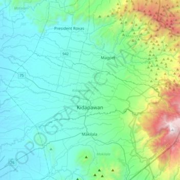
Nom : Carte topographique Kidapawan, altitude, relief.
Lieu : Kidapawan, North Cotabato, Soccsksargen, 9400, Philippines (6.97163 124.93130 7.11145 125.27078)
Altitude moyenne : 494 m
Altitude minimum : 33 m
Altitude maximum : 2.603 m
Autres cartes topographiques
Cliquez sur une carte pour visualiser sa topographie, son altitude et son relief.