
Carte topographique Camiling
Cliquez sur la carte pour afficher l’altitude.
Camiling
Mostly of plain topography but some parts are hilly to mountainous in which the barangays of Papaac, Bacsay, Birbira and Cayasan, to name a few. The deeper part of the mountains can be described as a place where wild animals live, such as deer, Toddy cat (Musang), wild boar (Baboy ramo), Monitor lizard (Bayawak).
À propos de cette carte
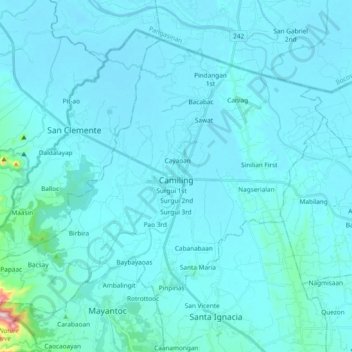
Nom : Carte topographique Camiling, altitude, relief.
Lieu : Camiling, Tarlac, Central Luzon, 2306, Philippines (15.61799 120.30535 15.75875 120.49339)
Altitude moyenne : 32 m
Altitude minimum : 8 m
Altitude maximum : 450 m
Autres cartes topographiques
Cliquez sur une carte pour visualiser sa topographie, son altitude et son relief.