
Carte topographique Capas
Cliquez sur la carte pour afficher l’altitude.
À propos de cette carte
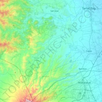
Nom : Carte topographique Capas, altitude, relief.
Lieu : Capas, Tarlac, Central Luzon, 2315, Philippines (15.24507 120.24593 15.42602 120.61788)
Altitude moyenne : 260 m
Altitude minimum : 33 m
Altitude maximum : 1.448 m
Autres cartes topographiques
Cliquez sur une carte pour visualiser sa topographie, son altitude et son relief.
Pura
Pura, just like any other town in the province of the Tarlac has two (2) pronounced seasons. The wet season that starts from May up to lasts up to September and dry from the month of October to April. This type of climate is typically hot, humid, and tropical and is generally affected by the neighboring…
Altitude moyenne : 23 m
Camiling
Mostly of plain topography but some parts are hilly to mountainous in which the barangays of Papaac, Bacsay, Birbira and Cayasan, to name a few. The deeper part of the mountains can be described as a place where wild animals live, such as deer, Toddy cat (Musang), wild boar (Baboy ramo), Monitor lizard…
Altitude moyenne : 32 m