
Faire un don
Équipez-vous pour votre prochaine aventure :
En tant que Partenaire Amazon, ce site perçoit une commission sur les achats éligibles sans surcoût pour vous.
Carte topographique North Backa Administrative District
Cliquez sur la carte pour afficher l’altitude.
Faire un don
Équipez-vous pour votre prochaine aventure :
En tant que Partenaire Amazon, ce site perçoit une commission sur les achats éligibles sans surcoût pour vous.
À propos de cette carte
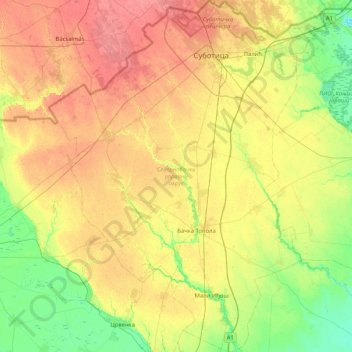
Nom : Carte topographique North Backa Administrative District, altitude, relief.
Lieu : North Backa Administrative District, Vojvodina, Serbia (45.61220 19.28160 46.19028 19.89597)
Altitude moyenne : 106 m
Altitude minimum : 76 m
Altitude maximum : 143 m
Faire un don
Équipez-vous pour votre prochaine aventure :
En tant que Partenaire Amazon, ce site perçoit une commission sur les achats éligibles sans surcoût pour vous.
Autres cartes topographiques
Cliquez sur une carte pour visualiser sa topographie, son altitude et son relief.
Subotica
Serbia > Vojvodina > North Backa Administrative District
It is located in Central Europe at the Pannonian Basin at 46.07° North, 19.68° East, at the altitude of 109m, about 10 kilometres (6 miles) from the border with Hungary, and is the northernmost city in Serbia. Lake Palić is in the immediate vicinity of the city. Sand dunes area Subotička Peščara is…
Altitude moyenne : 115 m
Fruška gora
Serbia > Vojvodina > South Backa Administrative District > Beocin Municipality
Altitude moyenne : 437 m
Subotica
Serbia > Vojvodina > North Backa Administrative District
It is located in Central Europe at the Pannonian Basin at 46.07° North, 19.68° East, at the altitude of 109m, about 10 kilometres (6 miles) from the border with Hungary, and is the northernmost city in Serbia. Lake Palić is in the immediate vicinity of the city. Sand dunes area Subotička Peščara is…
Altitude moyenne : 115 m
Faire un don
Équipez-vous pour votre prochaine aventure :
En tant que Partenaire Amazon, ce site perçoit une commission sur les achats éligibles sans surcoût pour vous.
Agla
Serbia > Vojvodina > South Backa Administrative District > Titel Municipality > Gardinovci
Altitude moyenne : 76 m
Пуцкарош
Serbia > Vojvodina > South Backa Administrative District > Petrovaradin
Altitude moyenne : 112 m
Baranda
Serbia > Vojvodina > South Banat Administrative District > Opovo Municipality
Altitude moyenne : 75 m
Цигански логор
Serbia > Vojvodina > Srem Administrative District > Lezimir > Багрењак
Altitude moyenne : 309 m
Faire un don
Équipez-vous pour votre prochaine aventure :
En tant que Partenaire Amazon, ce site perçoit une commission sur les achats éligibles sans surcoût pour vous.
Subotica
Serbia > Vojvodina > North Backa Administrative District
It is located in the Pannonian Basin at 46.07° North, 19.68° East, at the altitude of 109m, about 10 kilometres (6 miles) from the border with Hungary, and is the northernmost city in Serbia. Lake Palić is in the immediate vicinity of the city. Sand dunes area Subotička Peščara is located north of the…
Altitude moyenne : 115 m
Banstol
Serbia > Vojvodina > South Backa Administrative District > Sremski Karlovci Municipality
Altitude moyenne : 222 m
Subotica
Serbia > Vojvodina > North Backa Administrative District
It is located in the Pannonian Basin at 46.07° North, 19.68° East, at the altitude of 109m, about 10 kilometres (6 miles) from the border with Hungary, and is the northernmost city in Serbia. Lake Palić is in the immediate vicinity of the city. Sand dunes area Subotička Peščara is located north of the…
Altitude moyenne : 115 m
Брдеж до
Serbia > Vojvodina > Srem Administrative District > Indjija Municipality > Cortanovci
Altitude moyenne : 215 m
Faire un don
Équipez-vous pour votre prochaine aventure :
En tant que Partenaire Amazon, ce site perçoit une commission sur les achats éligibles sans surcoût pour vous.
Indjija
Serbia > Vojvodina > Srem Administrative District > Indjija Municipality
Altitude moyenne : 110 m
Beska
Serbia > Vojvodina > Srem Administrative District > Indjija Municipality
Altitude moyenne : 128 m
Maradik
Serbia > Vojvodina > Srem Administrative District > Indjija Municipality
Altitude moyenne : 157 m
Stara Pazova
Serbia > Vojvodina > Srem Administrative District > Stara Pazova Municipality
Altitude moyenne : 83 m
Faire un don
Équipez-vous pour votre prochaine aventure :
En tant que Partenaire Amazon, ce site perçoit une commission sur les achats éligibles sans surcoût pour vous.
Bač
Serbia > Vojvodina > South Backa Administrative District > Bac Municipality
Altitude moyenne : 83 m
Deronje
Serbia > Vojvodina > West Backa Administrative District > Odzaci Municipality
Altitude moyenne : 83 m
Faire un don
Équipez-vous pour votre prochaine aventure :
En tant que Partenaire Amazon, ce site perçoit une commission sur les achats éligibles sans surcoût pour vous.
Alibunar
Serbia > Vojvodina > South Banat Administrative District > Alibunar Municipality
Altitude moyenne : 101 m
Senta
Serbia > Vojvodina > North Banat Administrative District > Senta Municipality
Altitude moyenne : 80 m
Faire un don
Équipez-vous pour votre prochaine aventure :
En tant que Partenaire Amazon, ce site perçoit une commission sur les achats éligibles sans surcoût pour vous.
Backi Jarak
Serbia > Vojvodina > South Backa Administrative District > Temerin Municipality
Altitude moyenne : 81 m
Fruška gora
Serbia > Vojvodina > South Backa Administrative District > Beocin Municipality
Altitude moyenne : 437 m
Gudurički vrh
Serbia > Vojvodina > South Banat Administrative District > City of Vršac
Altitude moyenne : 330 m
Apatin
Serbia > Vojvodina > West Backa Administrative District > Apatin Municipality
Altitude moyenne : 85 m
Faire un don
Équipez-vous pour votre prochaine aventure :
En tant que Partenaire Amazon, ce site perçoit une commission sur les achats éligibles sans surcoût pour vous.
Sremski Karlovci
Serbia > Vojvodina > South Backa Administrative District > Sremski Karlovci Municipality > Sremski Karlovci
Altitude moyenne : 130 m
Backi Petrovac
Serbia > Vojvodina > South Backa Administrative District > Backi Petrovac Municipality
Altitude moyenne : 82 m
Faire un don
Équipez-vous pour votre prochaine aventure :
En tant que Partenaire Amazon, ce site perçoit une commission sur les achats éligibles sans surcoût pour vous.
Becej
Serbia > Vojvodina > South Backa Administrative District > Becej Municipality
Altitude moyenne : 78 m
Kula
Serbia > Vojvodina > West Backa Administrative District > Kula Municipality > Kula
Altitude moyenne : 89 m
Krnjesevci
Serbia > Vojvodina > Srem Administrative District > Stara Pazova Municipality
Altitude moyenne : 76 m
Faire un don
Équipez-vous pour votre prochaine aventure :
En tant que Partenaire Amazon, ce site perçoit une commission sur les achats éligibles sans surcoût pour vous.