
Faire un don
Équipez-vous pour votre prochaine aventure :
En tant que Partenaire Amazon, ce site perçoit une commission sur les achats éligibles sans surcoût pour vous.
Carte topographique Ledinci
Cliquez sur la carte pour afficher l’altitude.
Faire un don
Équipez-vous pour votre prochaine aventure :
En tant que Partenaire Amazon, ce site perçoit une commission sur les achats éligibles sans surcoût pour vous.
À propos de cette carte
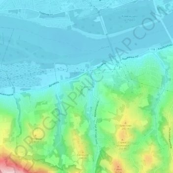
Nom : Carte topographique Ledinci, altitude, relief.
Altitude moyenne : 128 m
Altitude minimum : 71 m
Altitude maximum : 341 m
Faire un don
Équipez-vous pour votre prochaine aventure :
En tant que Partenaire Amazon, ce site perçoit une commission sur les achats éligibles sans surcoût pour vous.
Autres cartes topographiques
Cliquez sur une carte pour visualiser sa topographie, son altitude et son relief.
Bačka Palanka
Serbia > Vojvodina > South Backa Administrative District > Backa Palanka Municipality
Altitude moyenne : 89 m
Žabalj
Serbia > Vojvodina > South Backa Administrative District > Општина Жабаљ
Altitude moyenne : 78 m
Faire un don
Équipez-vous pour votre prochaine aventure :
En tant que Partenaire Amazon, ce site perçoit une commission sur les achats éligibles sans surcoût pour vous.
Novi Sad
Serbia > Vojvodina > South Backa Administrative District
The city lies on the meander of the river Danube, which is only 350 meters wide beneath the marking stones of Petrovaradin. A section of the Danube-Tisza-Danube Canal marks the northern edge of the wider city centre. The main part of the city lies on the left bank of the Danube in the region of Bačka, while…
Altitude moyenne : 83 m
Agla
Serbia > Vojvodina > South Backa Administrative District > Titel Municipality > Gardinovci
Altitude moyenne : 76 m
Vizic
Serbia > Vojvodina > South Backa Administrative District > Backa Palanka Municipality
Altitude moyenne : 196 m
Beocin
Serbia > Vojvodina > South Backa Administrative District > Beocin Municipality
Altitude moyenne : 226 m
Faire un don
Équipez-vous pour votre prochaine aventure :
En tant que Partenaire Amazon, ce site perçoit une commission sur les achats éligibles sans surcoût pour vous.
Novi Sad
Serbia > Vojvodina > South Backa Administrative District
The city lies on the meander of the river Danube, which is only 350 meters wide beneath the marking stones of Petrovaradin. A section of the Danube-Tisza-Danube Canal marks the northern edge of the wider city centre. The main part of the city lies on the left bank of the Danube in the region of Bačka, while…
Altitude moyenne : 83 m
Maglic
Serbia > Vojvodina > South Backa Administrative District > Backi Petrovac Municipality
Altitude moyenne : 83 m
Novi Sad
Serbia > Vojvodina > South Backa Administrative District
The city lies on the meander of the river Danube, which is only 350 meters wide beneath the marking stones of Petrovaradin. A section of the Danube-Tisza-Danube Canal marks the northern edge of the wider city centre. The main part of the city lies on the left bank of the Danube in the region of Bačka, while…
Altitude moyenne : 83 m
Gardinovci
Serbia > Vojvodina > South Backa Administrative District > Titel Municipality
Altitude moyenne : 78 m
Faire un don
Équipez-vous pour votre prochaine aventure :
En tant que Partenaire Amazon, ce site perçoit une commission sur les achats éligibles sans surcoût pour vous.
Bačka Palanka
Serbia > Vojvodina > South Backa Administrative District > Backa Palanka Municipality
Altitude moyenne : 89 m
Backi Jarak
Serbia > Vojvodina > South Backa Administrative District > Temerin Municipality
Altitude moyenne : 82 m
Backi Jarak
Serbia > Vojvodina > South Backa Administrative District > Temerin Municipality
Altitude moyenne : 82 m
Faire un don
Équipez-vous pour votre prochaine aventure :
En tant que Partenaire Amazon, ce site perçoit une commission sur les achats éligibles sans surcoût pour vous.
Novi Sad
Serbia > Vojvodina > South Backa Administrative District
The city lies on the meander of the river Danube, which is only 350 meters wide beneath the marking stones of Petrovaradin. A section of the Danube-Tisza-Danube Canal marks the northern edge of the wider city centre. The main part of the city lies on the left bank of the Danube in the region of Bačka, while…
Altitude moyenne : 83 m
Becej
Serbia > Vojvodina > South Backa Administrative District > Becej Municipality
Altitude moyenne : 79 m
Sremski Karlovci Municipality
Serbia > Vojvodina > South Backa Administrative District
Altitude moyenne : 178 m
Novi Sad
Serbia > Vojvodina > South Backa Administrative District
The city lies on the meander of the river Danube, which is only 350 meters wide beneath the marking stones of Petrovaradin. A section of the Danube-Tisza-Danube Canal marks the northern edge of the wider city centre. The main part of the city lies on the left bank of the Danube in the region of Bačka, while…
Altitude moyenne : 83 m
Faire un don
Équipez-vous pour votre prochaine aventure :
En tant que Partenaire Amazon, ce site perçoit une commission sur les achats éligibles sans surcoût pour vous.
Petrovaradin
Serbia > Vojvodina > South Backa Administrative District
Petrovaradin is located in the Syrmia region, on the Danube river and Fruška Gora, a horst mountain with elevation of 78–220 m (municipality up to 451 m). The northern part of Fruška Gora consists of massive landslide zones, but they are not active, except in Ribnjak neighborhood (between Sremska Kamenica…
Altitude moyenne : 105 m
Novi Sad
Serbia > Vojvodina > South Backa Administrative District
The city lies on the meander of the river Danube, which is only 350 meters wide beneath the marking stones of Petrovaradin. A section of the Danube-Tisza-Danube Canal marks the northern edge of the wider city centre. The main part of the city lies on the left bank of the Danube in the region of Bačka, while…
Altitude moyenne : 83 m
Faire un don
Équipez-vous pour votre prochaine aventure :
En tant que Partenaire Amazon, ce site perçoit une commission sur les achats éligibles sans surcoût pour vous.