
Carte topographique Nyaung-U District
Carte interactive
Cliquez sur la carte pour afficher l’altitude.
À propos de cette carte
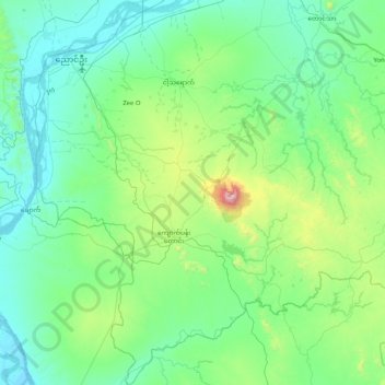
Nom : Carte topographique Nyaung-U District, altitude, relief.
Lieu : Nyaung-U District, Mandalay, Myanmar (20.54268 94.82973 21.31370 95.54460)
Altitude moyenne : 255 m
Altitude minimum : 39 m
Altitude maximum : 1.480 m
Autres cartes topographiques
Cliquez sur une carte pour visualiser sa topographie, son altitude et son relief.
Singu Township
Singu Township, Pyin Oo Lwin District, Mandalay, Myanmar
Altitude moyenne : 294 m
Myingyan Township
Myingyan Township, Myingyan District, Mandalay, 05251, Myanmar
Altitude moyenne : 107 m