
Carte topographique Blatten
Carte interactive
Cliquez sur la carte pour afficher l’altitude.
À propos de cette carte
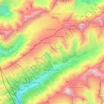
Nom : Carte topographique Blatten, altitude, relief.
Lieu : Blatten, Westlich Raron, Wallis, 3919, Switzerland (46.38912 7.76850 46.49825 7.96555)
Altitude moyenne : 2.536 m
Altitude minimum : 1.267 m
Altitude maximum : 3.905 m
Blatten lies in the Lötschental valley south of the Bernese Alps. The municipality is located in the Westlich Raron district, and is the highest inhabited part of the Lötschental valley at an elevation of 1,540 m (5,050 ft). It consists of the village of Blatten and the hamlets of Eisten, Ried and Weissenried. At the head of the road up the valley, Fafleralp is the site of a well known hotel.
Autres cartes topographiques
Cliquez sur une carte pour visualiser sa topographie, son altitude et son relief.
Grosshorn
Switzerland > Wallis > Westlich Raron > Blatten
Grosshorn, Blatten, Westlich Raron, Wallis, 3919, Switzerland
Altitude moyenne : 3.073 m
Lauchernalp
Switzerland > Wallis > Westlich Raron
Lauchernalp, Wiler (Lötschen), Westlich Raron, Wallis, 3918, Switzerland
Altitude moyenne : 1.956 m
Raron
Switzerland > Wallis > Westlich Raron
Raron, Westlich Raron, Wallis, 3942, Switzerland
Altitude moyenne : 1.712 m
Breithorn
Switzerland > Wallis > Westlich Raron > Blatten
Breithorn, Blatten, Westlich Raron, Wallis, 3919, Switzerland
Altitude moyenne : 2.914 m