
Carte topographique Grosshorn
Carte interactive
Cliquez sur la carte pour afficher l’altitude.
À propos de cette carte
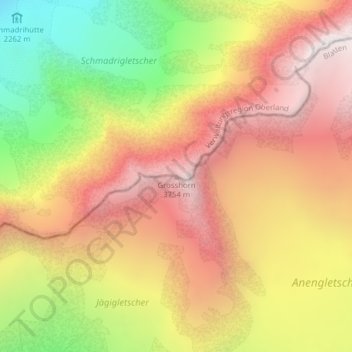
Nom : Carte topographique Grosshorn, altitude, relief.
Lieu : Grosshorn, Blatten, Westlich Raron, Wallis, 3919, Switzerland (46.48693 7.91003 46.48703 7.91013)
Altitude moyenne : 3.073 m
Altitude minimum : 2.155 m
Altitude maximum : 3.794 m
Autres cartes topographiques
Cliquez sur une carte pour visualiser sa topographie, son altitude et son relief.
Breithorn
Switzerland > Wallis > Westlich Raron > Blatten
Breithorn, Blatten, Westlich Raron, Wallis, 3919, Switzerland
Altitude moyenne : 2.914 m